IMAGES TAKEN NEAR TO
Nutfield Marsh Road, REDHILL, RH1 4ET
Introduction
This page details the photographs taken nearby to Nutfield Marsh Road, RH1 4ET by members of the Geograph project.
The Geograph project started in 2005 with the aim of publishing, organising and preserving representative images for every square kilometre of Great Britain, Ireland and the Isle of Man.

There are currently over 7.5m images from over14,400 individuals and you can help contribute to the project by visiting https://www.geograph.org.uk
Image Map (Loading...)


Getting Data...Please wait
Leaflet Map data © OpenStreetMap
Images are licensed for reuse under creativecommons.org/licenses/by-sa/2.0
Notes
- Clicking on the map will re-center to the selected point.
- The higher the marker number, the further away the image location is from the centre of the postcode.
Image Listing (35 Images Found)
Images are licensed for reuse under creativecommons.org/licenses/by-sa/2.0
Image
Details
Distance
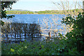
2

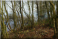
Mercers Lake
A flooded former gravel pit now forming the centrepiece of Mercers Country Park.
Image: © Bill Boaden
Taken: 16 May 2019
0.04 miles
3

Mercers Park Country Park, Nutfield Marsh, Surrey
Down the bank, and accessed via another gate, two jetties give anglers access to fishing in the lake.
Image: © Peter Trimming
Taken: 10 Dec 2013
0.06 miles
5
Mercers Park Country Park, Nutfield Marsh, Surrey
There are a couple of nearby bench seats, which enjoy a view similar to this. Looks like the trees need to be coppiced, in order to re-open the view across the lake.
Image: © Peter Trimming
Taken: 10 Dec 2013
0.12 miles
6
Mercers Lake
A flooded former gravel pit, now part of a country park.
Image: © Bill Boaden
Taken: 16 May 2019
0.16 miles
7
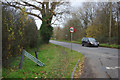
Cormongers Lane, South Merstham
This is where Cormongers Lane joins Nutfield Road. The name sign is in a bad way and the speed restriction sign doesn't look too healthy either. The word cormongers is obscure - it may possibly have referred to a purveyor of offal, but why this road should take the name is unknown.
Image: © Stephen McKay
Taken: 22 Nov 2017
0.17 miles
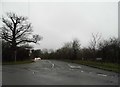
8

Junction of Nutfield Marsh Road and Cormongers Lane
Image: © Robert Eva
Taken: 18 Jul 2017
0.17 miles
9
Cormongers Lane at the junction of Nutfield Marsh Road
Image: © David Howard
Taken: 24 Jan 2016
0.17 miles