IMAGES TAKEN NEAR TO
Hillfield Road, REDHILL, RH1 4AP
Introduction
This page details the photographs taken nearby to Hillfield Road, RH1 4AP by members of the Geograph project.
The Geograph project started in 2005 with the aim of publishing, organising and preserving representative images for every square kilometre of Great Britain, Ireland and the Isle of Man.

There are currently over 7.5m images from over14,400 individuals and you can help contribute to the project by visiting https://www.geograph.org.uk
Image Map (Loading...)


Getting Data...Please wait
Leaflet Map data © OpenStreetMap
Images are licensed for reuse under creativecommons.org/licenses/by-sa/2.0
Notes
- Clicking on the map will re-center to the selected point.
- The higher the marker number, the further away the image location is from the centre of the postcode.
Image Listing (232 Images Found)
Images are licensed for reuse under creativecommons.org/licenses/by-sa/2.0
Image
Details
Distance
1
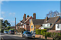
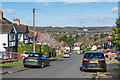
Hillfield Road
Road in the Redstone Hill area of Redhill. It originally ended around this point, with the large Edwardian house in the background, now split into two as Oakfield and Oaklands, marking the end of the road. The nearer houses are more recent, being a later fill in following the extension of the road in the c.1930s with the development of Redstone Park.
Image: © Ian Capper
Taken: 1 Mar 2020
0.02 miles
2
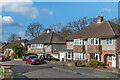
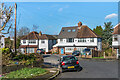
Oakwood Close
c.1930s housing in the Redstone Hill area of Redhill. The name derives from that of a large house previously on the site, called Oakwood.
Image: © Ian Capper
Taken: 1 Mar 2020
0.06 miles
3
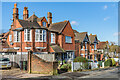
Crossland Road
Edwardian housing in the Redstone Hill area of Redhill.
Image: © Ian Capper
Taken: 1 Mar 2020
0.06 miles
4
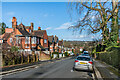
Crossland Road
Edwardian housing in the Redstone Hill area of Redhill.
Image: © Ian Capper
Taken: 1 Mar 2020
0.06 miles
5
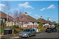
Redstone Park
c.1930s housing in the Redstone Hill area of Redhill. In the distance can be seen Gatton Hall.
Image: © Ian Capper
Taken: 1 Mar 2020
0.07 miles
6
Hillfield Close
c.1930s housing at the bottom of Redstone Park in the Redstone Hill area of Redhill.
Image: © Ian Capper
Taken: 1 Mar 2020
0.07 miles
8
Oakwood Close
c.1930s housing in the Redstone Hill area of Redhill. The name derives from that of a large house previously on the site, called Oakwood.
Image: © Ian Capper
Taken: 1 Mar 2020
0.10 miles
9
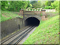
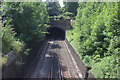
Redhill Tunnel
North portal of the 649 yard Redhill Tunnel. Dating from 1900, it was part of the so called Quarry Line built by the London Brighton and South Coast Railway, bypassing the original line through Merstham and Redhill owned by the South Eastern Railway. The Quarry Line now serves as the fast lines from London Bridge/Victoria to Gatwick Airport and Brighton.
Image: © Ian Capper
Taken: 4 May 2009
0.10 miles
10
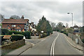
A25 Redstone Hill, Redhill
Climbing out of the town to the east.
Image: © Robin Webster
Taken: 23 Mar 2019
0.12 miles