IMAGES TAKEN NEAR TO
Noke Drive, REDHILL, RH1 4AD
Introduction
This page details the photographs taken nearby to Noke Drive, RH1 4AD by members of the Geograph project.
The Geograph project started in 2005 with the aim of publishing, organising and preserving representative images for every square kilometre of Great Britain, Ireland and the Isle of Man.

There are currently over 7.5m images from over14,400 individuals and you can help contribute to the project by visiting https://www.geograph.org.uk
Image Map
Images are licensed for reuse under creativecommons.org/licenses/by-sa/2.0
Notes
- Clicking on the map will re-center to the selected point.
- The higher the marker number, the further away the image location is from the centre of the postcode.
Image Listing (198 Images Found)
Images are licensed for reuse under creativecommons.org/licenses/by-sa/2.0
Image
Details
Distance
1
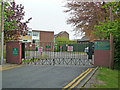
The Warwick School
Formerly Redstone School, this is a non-denominational mixed secondary school for 11 to 16 years. The name refers to the name used for the first stage of the development of Redhill following the arrival of the railway in the mid 19th century, Warwick Town, although in terms of locations, Redstone seemed more fitting.
It was the first school in South East Surrey to gain Specialist Technology College status.
Image: © Ian Capper
Taken: 4 May 2009
0.04 miles
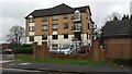
2
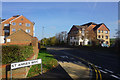
St Anne's Drive
In contrast with the other roads on this development named after St Anne, there does seem to be an apostrophe in St Anne's Drive.
Image: © Bill Boaden
Taken: 11 Nov 2016
0.06 miles
3
Apartments on St Annes Way
Most times I see it locally, there is no apostrophe in St Annes.
Image: © Bill Boaden
Taken: 11 Nov 2016
0.07 miles
4
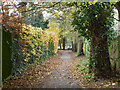
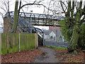
Footpath from Ladbroke Road to St. Annes's Drive
Via a footbridge over the railway.
Image: © Robin Webster
Taken: 17 Nov 2010
0.08 miles
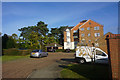
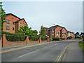
5
St Anne's Drive
1990s housing built on the grounds of St Anne's, an imposing building dating from 1884, housing in turn a school, a hospital and finally a County Council run old people's home. It was demolished in 1987. The name lives on in the name of this road and its side roads.
Image: © Ian Capper
Taken: 4 May 2009
0.08 miles
6
St Anne's Drive
1990s housing built on the grounds of St Anne's, an imposing building dating from 1884, housing in turn a school, a hospital and finally a County Council run old people's home. It was demolished in 1987. The name lives on in the name of this road and its side roads.
Image: © Ian Capper
Taken: 4 May 2009
0.08 miles
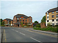
7
Modern apartment blocks in St Anne's Drive
Image: © David Martin
Taken: 18 Dec 2015
0.08 miles
8
Footpath over railway, Redhill
From St. Annes's Drive to Ladbroke Road.
Image: © Robin Webster
Taken: 17 Nov 2010
0.12 miles
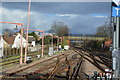
9
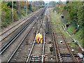
Work on points, Redhill
Looking towards London.
Image: © Robin Webster
Taken: 17 Nov 2010
0.12 miles