IMAGES TAKEN NEAR TO
Hedgelands, RH14 9XS
Introduction
This page details the photographs taken nearby to Hedgelands, RH14 9XS by members of the Geograph project.
The Geograph project started in 2005 with the aim of publishing, organising and preserving representative images for every square kilometre of Great Britain, Ireland and the Isle of Man.

There are currently over 7.5m images from over14,400 individuals and you can help contribute to the project by visiting https://www.geograph.org.uk
Image Map
Images are licensed for reuse under creativecommons.org/licenses/by-sa/2.0
Notes
- Clicking on the map will re-center to the selected point.
- The higher the marker number, the further away the image location is from the centre of the postcode.
Image Listing (19 Images Found)
Images are licensed for reuse under creativecommons.org/licenses/by-sa/2.0
Image
Details
Distance
1
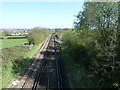
Line between Littlehampton and Horsham
Viewed from bridge near Denham's Farm the line is approaching Billingshurst.
Image: © Dave Spicer
Taken: 9 Apr 2011
0.08 miles
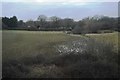
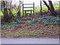
2
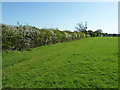
Footpath between Little Gillmans Farm and Denham's Farm
Image: © Dave Spicer
Taken: 9 Apr 2011
0.10 miles
3
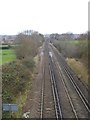
Looking north from the rail bridge at Denham's Farm
The view extends into the next grid square to the north and the spire of Billinghurst church can be made out in the centre of the skyline.
Image: © Shazz
Taken: 17 Dec 2015
0.12 miles
9
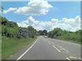
A29 approaches roundabout junction with Stane Street
Image: © Stuart Logan
Taken: 29 Jun 2014
0.18 miles
10
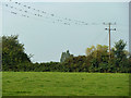
Swallows thinking it's time to go
A fair proportion (all?) of these were born and bred in Billingshurst but they will desert it for the winter.
Image: © Robin Webster
Taken: 2 Sep 2011
0.18 miles