IMAGES TAKEN NEAR TO
Briar Lane, BILLINGSHURST, RH14 9XN
Introduction
This page details the photographs taken nearby to Briar Lane, RH14 9XN by members of the Geograph project.
The Geograph project started in 2005 with the aim of publishing, organising and preserving representative images for every square kilometre of Great Britain, Ireland and the Isle of Man.

There are currently over 7.5m images from over14,400 individuals and you can help contribute to the project by visiting https://www.geograph.org.uk
Image Map
Images are licensed for reuse under creativecommons.org/licenses/by-sa/2.0
Notes
- Clicking on the map will re-center to the selected point.
- The higher the marker number, the further away the image location is from the centre of the postcode.
Image Listing (7 Images Found)
Images are licensed for reuse under creativecommons.org/licenses/by-sa/2.0
Image
Details
Distance
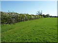
1
Houses at the southern edge of Billingshurst
The houses are in Kingsfold Close while the very neatly trimmed hedge borders Marringdean Road.
Image: © Dave Spicer
Taken: 9 Apr 2011
0.04 miles
3
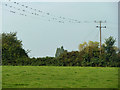
Swallows thinking it's time to go
A fair proportion (all?) of these were born and bred in Billingshurst but they will desert it for the winter.
Image: © Robin Webster
Taken: 2 Sep 2011
0.16 miles
4
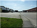
Gillmans Industrial Estate
Off Natts Lane.
Image: © Dave Spicer
Taken: 9 Apr 2011
0.20 miles
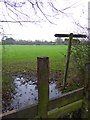
5
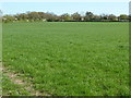
Footpath between Little Gillmans Farm and Denham's Farm
Image: © Dave Spicer
Taken: 9 Apr 2011
0.22 miles
6
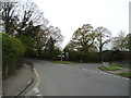
Lower Station Road, junction with Natts Lane, Billingshurst
Image: © Stacey Harris
Taken: 4 May 2012
0.24 miles
7
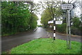
Fingerpost, Natts Lane and Lower Station Rd junction
Image: © N Chadwick
Taken: 6 May 2012
0.25 miles