IMAGES TAKEN NEAR TO
The Willows, BILLINGSHURST, RH14 9WL
Introduction
This page details the photographs taken nearby to The Willows, RH14 9WL by members of the Geograph project.
The Geograph project started in 2005 with the aim of publishing, organising and preserving representative images for every square kilometre of Great Britain, Ireland and the Isle of Man.

There are currently over 7.5m images from over14,400 individuals and you can help contribute to the project by visiting https://www.geograph.org.uk
Image Map
Images are licensed for reuse under creativecommons.org/licenses/by-sa/2.0
Notes
- Clicking on the map will re-center to the selected point.
- The higher the marker number, the further away the image location is from the centre of the postcode.
Image Listing (21 Images Found)
Images are licensed for reuse under creativecommons.org/licenses/by-sa/2.0
Image
Details
Distance
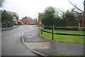
1
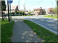
Mini-roundabout for Natts Lane and Stane Street junction
Image: © Dave Spicer
Taken: 9 Apr 2011
0.06 miles

3
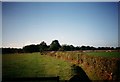
Farmland at Parbrook, Billingshurst
Taken to the side of the playing fields, now has estate of new houses.
Footpath number 1313
Image: © Geographer
Taken: 7 Oct 1990
0.08 miles
4
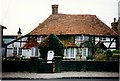
Fossbrooks, Parbrook
On Stane Street
17th Century Grade 2 listed house
Image: © Geographer
Taken: Unknown
0.08 miles
5
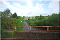
Natts Lane
Taken from the Arun Valley Line.
Image: © N Chadwick
Taken: 8 May 2011
0.12 miles
7
Traffic lights at the junction of Luxford Way and Stane Street
Stane Street was the former A29 before the bypass was built.
Image: © Dave Spicer
Taken: 9 Apr 2011
0.13 miles
8
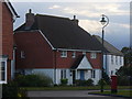
Parbrook, Billingshurst
Modern housing estate with attractive tile-hung homes. It fills in the area between the old main road and the new bypass.
Image: © Colin Smith
Taken: 6 Nov 2010
0.15 miles
9
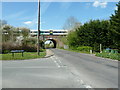
Southbound train having just left Billingshurst Station
The bridge is over Natts Lane and amongst the trees on the right is Par Brook which gives it name to Parbrook, part of Billingshurst.
Image: © Dave Spicer
Taken: 9 Apr 2011
0.15 miles
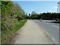
10
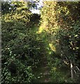
Footpath climbs embankment
The footpath out of Billingshurst climbs up the embankment with steps to cross the A29.
Image: © Chris Thomas-Atkin
Taken: 27 Aug 2017
0.19 miles