IMAGES TAKEN NEAR TO
Chestnut Road, BILLINGSHURST, RH14 9SY
Introduction
This page details the photographs taken nearby to Chestnut Road, RH14 9SY by members of the Geograph project.
The Geograph project started in 2005 with the aim of publishing, organising and preserving representative images for every square kilometre of Great Britain, Ireland and the Isle of Man.

There are currently over 7.5m images from over14,400 individuals and you can help contribute to the project by visiting https://www.geograph.org.uk
Image Map
Images are licensed for reuse under creativecommons.org/licenses/by-sa/2.0
Notes
- Clicking on the map will re-center to the selected point.
- The higher the marker number, the further away the image location is from the centre of the postcode.
Image Listing (83 Images Found)
Images are licensed for reuse under creativecommons.org/licenses/by-sa/2.0
Image
Details
Distance
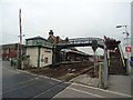
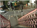
1
Billingshurst Station
Early evening (15.00) gloaming in November.
Image: © Stanley Howe
Taken: 3 Nov 2005
0.03 miles
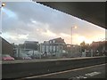
2
My down-train departs Billingshurst
As seen from the passenger footbridge at Billingshurst Station.
Image: © Stanley Howe
Taken: 3 Nov 2005
0.03 miles

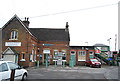
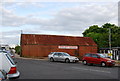
4
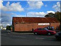
Station Garage Billingshurst.
A typical building found near railway stations around the south.
Image: © Matt Fisher esq
Taken: 24 Sep 2007
0.05 miles
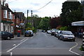
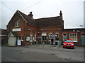
7

Lower Station Road, Billingshurst
Looking towards the station.
No. 12 (Lynwood) is on the left.
Image: © Stephen Richards
Taken: 6 Apr 2015
0.07 miles