IMAGES TAKEN NEAR TO
Silver Lane, BILLINGSHURST, RH14 9RJ
Introduction
This page details the photographs taken nearby to Silver Lane, RH14 9RJ by members of the Geograph project.
The Geograph project started in 2005 with the aim of publishing, organising and preserving representative images for every square kilometre of Great Britain, Ireland and the Isle of Man.

There are currently over 7.5m images from over14,400 individuals and you can help contribute to the project by visiting https://www.geograph.org.uk
Image Map
Images are licensed for reuse under creativecommons.org/licenses/by-sa/2.0
Notes
- Clicking on the map will re-center to the selected point.
- The higher the marker number, the further away the image location is from the centre of the postcode.
Image Listing (73 Images Found)
Images are licensed for reuse under creativecommons.org/licenses/by-sa/2.0
Image
Details
Distance
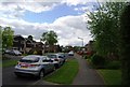
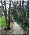
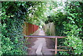
2
Church Path, Billingshurst (2)
A useful link between Station Road and the High Street.
The wall belonged to a big Victorian house demolished in the 1970s for the new houses which now lie beyond at Clevelands.
Image: © Stephen Richards
Taken: 6 Apr 2015
0.12 miles
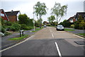
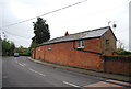
6
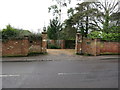
Entry to Knights and Knights Acre
Off Station Road
Image: © The Saunterer
Taken: 23 Dec 2012
0.14 miles
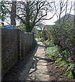
8
Church Path, Billingshurst (1)
A useful link between Station Road and the High Street.
Image: © Stephen Richards
Taken: 6 Apr 2015
0.15 miles
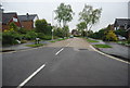
10
Stile as the footpath enters Billingshurst
Image: © N Chadwick
Taken: 3 May 2009
0.15 miles