IMAGES TAKEN NEAR TO
Forge Way, BILLINGSHURST, RH14 9LL
Introduction
This page details the photographs taken nearby to Forge Way, RH14 9LL by members of the Geograph project.
The Geograph project started in 2005 with the aim of publishing, organising and preserving representative images for every square kilometre of Great Britain, Ireland and the Isle of Man.

There are currently over 7.5m images from over14,400 individuals and you can help contribute to the project by visiting https://www.geograph.org.uk
Image Map
Images are licensed for reuse under creativecommons.org/licenses/by-sa/2.0
Notes
- Clicking on the map will re-center to the selected point.
- The higher the marker number, the further away the image location is from the centre of the postcode.
Image Listing (48 Images Found)
Images are licensed for reuse under creativecommons.org/licenses/by-sa/2.0
Image
Details
Distance
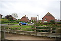
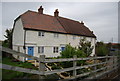
5
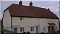
Cottages in Billingshurst
These cottages are by the A29 footbridge, the fence of which is in the bottom LH corner of the picture.
Image: © Shazz
Taken: 17 Oct 2009
0.08 miles
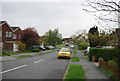
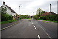
10
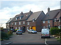
Residential Billingshurst
Modern housing in the Low Weald. The housing estate fills the area between Billingshurst's bypass and the High Street (formerly Stane Street).
Image: © Colin Smith
Taken: 6 Nov 2010
0.10 miles