IMAGES TAKEN NEAR TO
Marringdean Road, BILLINGSHURST, RH14 9HF
Introduction
This page details the photographs taken nearby to Marringdean Road, RH14 9HF by members of the Geograph project.
The Geograph project started in 2005 with the aim of publishing, organising and preserving representative images for every square kilometre of Great Britain, Ireland and the Isle of Man.

There are currently over 7.5m images from over14,400 individuals and you can help contribute to the project by visiting https://www.geograph.org.uk
Image Map
Images are licensed for reuse under creativecommons.org/licenses/by-sa/2.0
Notes
- Clicking on the map will re-center to the selected point.
- The higher the marker number, the further away the image location is from the centre of the postcode.
Image Listing (9 Images Found)
Images are licensed for reuse under creativecommons.org/licenses/by-sa/2.0
Image
Details
Distance
1
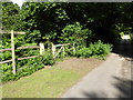
Gateway to Fowlers Field, footpath and wedding party
Image: © Shazz
Taken: 10 Aug 2016
0.07 miles
3
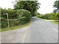
Looking north on Marringdean Road from footpath junction
Image: © Shazz
Taken: 10 Aug 2016
0.09 miles
4
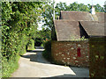
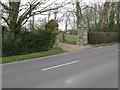
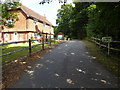
Lane by Marringdean House
A private road but public footpath. It gives access to several premises clustered around Marringdean House and Farm. Several houses in this area incorporate 'Marringdean' in their names. The mail box is not for outgoing mail, but incoming.
Image: © Robin Webster
Taken: 2 Sep 2011
0.10 miles
5
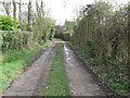
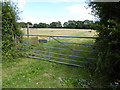
Footpath and track near Marringdean House
Image: © Dave Spicer
Taken: 7 Mar 2009
0.11 miles
6
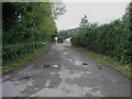
Footpath 1320 from Maringdean Road
Following the drive to Marringdean Farm and then cross-country to Gess Gates Farm on Stane Street (A29).
Image: © Andy Potter
Taken: 10 Oct 2006
0.13 miles
8
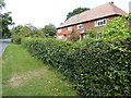
"Stonepits Lodge"
The private road is a public footpath.
Image: © Shazz
Taken: 10 Aug 2016
0.23 miles