IMAGES TAKEN NEAR TO
Marringdean Road, BILLINGSHURST, RH14 9HD
Introduction
This page details the photographs taken nearby to Marringdean Road, RH14 9HD by members of the Geograph project.
The Geograph project started in 2005 with the aim of publishing, organising and preserving representative images for every square kilometre of Great Britain, Ireland and the Isle of Man.

There are currently over 7.5m images from over14,400 individuals and you can help contribute to the project by visiting https://www.geograph.org.uk
Image Map
Images are licensed for reuse under creativecommons.org/licenses/by-sa/2.0
Notes
- Clicking on the map will re-center to the selected point.
- The higher the marker number, the further away the image location is from the centre of the postcode.
Image Listing (6 Images Found)
Images are licensed for reuse under creativecommons.org/licenses/by-sa/2.0
Image
Details
Distance
1
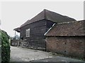
Kingslea Farm on Marringdean Road
All the old farm buildings by the road looked rather neglected.
Image: © Andy Potter
Taken: 10 Oct 2006
0.05 miles
2
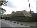
Farm buildings on Kinslea Farm
These buildings, along with the large wooden barn shown as Image sit empty around a moss covered farmyard. Seems such a waste.
Image: © Andy Potter
Taken: 10 Oct 2006
0.05 miles
3
Entrance to Kingsmead Farm and Silvester Eng
Image: © Dave Spicer
Taken: 9 Apr 2011
0.07 miles
4
Houses at the southern edge of Billingshurst
The houses are in Kingsfold Close while the very neatly trimmed hedge borders Marringdean Road.
Image: © Dave Spicer
Taken: 9 Apr 2011
0.19 miles
5
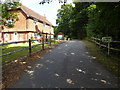
"Stonepits Lodge"
The private road is a public footpath.
Image: © Shazz
Taken: 10 Aug 2016
0.22 miles