IMAGES TAKEN NEAR TO
High Street, BILLINGSHURST, RH14 9EF
Introduction
This page details the photographs taken nearby to High Street, RH14 9EF by members of the Geograph project.
The Geograph project started in 2005 with the aim of publishing, organising and preserving representative images for every square kilometre of Great Britain, Ireland and the Isle of Man.

There are currently over 7.5m images from over14,400 individuals and you can help contribute to the project by visiting https://www.geograph.org.uk
Image Map
Images are licensed for reuse under creativecommons.org/licenses/by-sa/2.0
Notes
- Clicking on the map will re-center to the selected point.
- The higher the marker number, the further away the image location is from the centre of the postcode.
Image Listing (211 Images Found)
Images are licensed for reuse under creativecommons.org/licenses/by-sa/2.0
Image
Details
Distance
1
Stane Street
Part of the Roman road through Billingshurst. Once known as Alicks Hill and once the most photographed view in Billingshurst, postcards of which have been published in "Billingshurst, a Photographic History".
Image: © Matt Fisher esq
Taken: 21 Aug 2007
0.03 miles
2
Billingshurst Women's Hall
Donated to the women of the village in 1923; no longer used solely by women's groups.
Image: © David Smith
Taken: 9 Jul 2019
0.03 miles
4
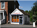
R.Rhodes & Sons
Shoes, leather goods and shoe repairs: a traditional shoe shop with repairs in the workshop in the back and connected to the proprietor's house to the left.
Image: © Andy Potter
Taken: 4 Aug 2007
0.04 miles
5
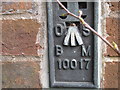
Ordnance Survey Flush Bracket 10017
This bracket can be found on a wall of Trinity Church, Billinghurst.
For more details see : http://www.bench-marks.org.uk/bm12974
Image: © Peter Wood
Taken: 4 Apr 2012
0.05 miles
6
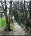
Church Path, Billingshurst (1)
A useful link between Station Road and the High Street.
Image: © Stephen Richards
Taken: 6 Apr 2015
0.05 miles
8
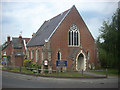
Trinity United Reformed Church
On the corner of West Street and the High Street, formerly the junction of the main east-west and north-south roads before the construction of the Billingshurst by-pass.
Image: © Andy Potter
Taken: 5 Jun 2010
0.06 miles
9
Ordnance Survey Bench mark
Flush Bracket. "FL BR 10017 BUTT TRINITY CH NW SIDE HIGH ST S FACE NE ANG 26.4561 metres, 0.6 metres above ground level" Trinity United Reformed Church.
Image: © The Saunterer
Taken: 23 Dec 2012
0.06 miles
10
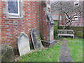
Graveyard of Billingshurst Unitarian Chapel
Image: © David Smith
Taken: 9 Jul 2019
0.06 miles