IMAGES TAKEN NEAR TO
Five Oaks, BILLINGSHURST, RH14 9BD
Introduction
This page details the photographs taken nearby to RH14 9BD by members of the Geograph project.
The Geograph project started in 2005 with the aim of publishing, organising and preserving representative images for every square kilometre of Great Britain, Ireland and the Isle of Man.

There are currently over 7.5m images from over14,400 individuals and you can help contribute to the project by visiting https://www.geograph.org.uk
Image Map
Images are licensed for reuse under creativecommons.org/licenses/by-sa/2.0
Notes
- Clicking on the map will re-center to the selected point.
- The higher the marker number, the further away the image location is from the centre of the postcode.
Image Listing (16 Images Found)
Images are licensed for reuse under creativecommons.org/licenses/by-sa/2.0
Image
Details
Distance
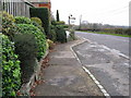
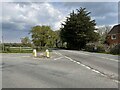
1
Haven Road joining the A 29 at Buckman Corner
With two legged horse sign in the background
Image: © Dave Spicer
Taken: 21 Nov 2009
0.07 miles
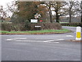
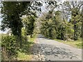
3
Stane Street at the junction of Haven Road
Image: © David Howard
Taken: 13 Sep 2015
0.07 miles
4
Stane Street
Stane Street at the junction with Haven Road at Buckman Corner.
Image: © Chris Thomas-Atkin
Taken: 30 Apr 2021
0.08 miles
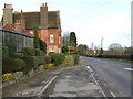
5
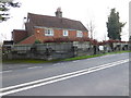
House at Buckman Corner
See http://www.geograph.org.uk/photo/4659086 from three months earlier.
Image: © Shazz
Taken: 28 Dec 2015
0.08 miles
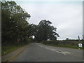
6
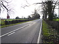
Stretch of the A29 just north of Buckman Corner
Image: © Shazz
Taken: 28 Dec 2015
0.08 miles
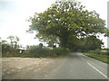
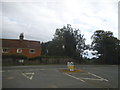
8
Haven Road
Heading northwards on Haven Road towards Bucks Green.
Image: © Chris Thomas-Atkin
Taken: 30 Apr 2021
0.11 miles
9
Bed and Breakfast at Five Oaks Farm
See http://www.geograph.org.uk/photo/1594129 from 2009.
Image: © Shazz
Taken: 28 Dec 2015
0.15 miles