IMAGES TAKEN NEAR TO
The Lane, BILLINGSHURST, RH14 0UL
Introduction
This page details the photographs taken nearby to The Lane, RH14 0UL by members of the Geograph project.
The Geograph project started in 2005 with the aim of publishing, organising and preserving representative images for every square kilometre of Great Britain, Ireland and the Isle of Man.

There are currently over 7.5m images from over14,400 individuals and you can help contribute to the project by visiting https://www.geograph.org.uk
Image Map
Images are licensed for reuse under creativecommons.org/licenses/by-sa/2.0
Notes
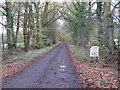
- Clicking on the map will re-center to the selected point.
- The higher the marker number, the further away the image location is from the centre of the postcode.
Image Listing (15 Images Found)
Images are licensed for reuse under creativecommons.org/licenses/by-sa/2.0
Image
Details
Distance
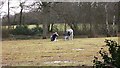
1
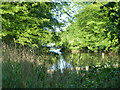
Lake, Ifold
It seems to be largely, possibly entirely, in the grounds of The Lake House.
Image: © Robin Webster
Taken: 3 May 2011
0.11 miles
2
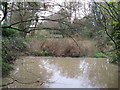
SW edge of The Lake
A very large house has recently been built close by.
Image: © Dave Spicer
Taken: 13 Nov 2010
0.13 miles
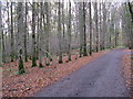
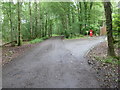
3
Bridleway only for The Lane
The metalled road ends at the corner behind the camera.
Image: © Dave Spicer
Taken: 13 Nov 2010
0.14 miles
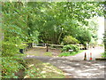
5
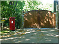
Gate to The Lake House
The post box is presumably second-hand, for deliveries to the house.
Image: © Robin Webster
Taken: 3 May 2011
0.15 miles
7
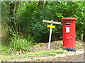
Beware of the Dog. GR
Sign and old post box on Forestry Road, Ifold, an upmarket rural residential area.
Image: © Colin Smith
Taken: 10 Sep 2011
0.16 miles
8
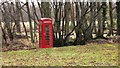
Telephone kiosk
I just bet this 'phone doesn't work.
Image: © Shazz
Taken: 24 Jan 2009
0.17 miles
9
The Lane, Ifold
Rural, residential area with secluded large houses - names, no numbers.
Image: © Colin Smith
Taken: 10 Sep 2011
0.17 miles