IMAGES TAKEN NEAR TO
The Drive, BILLINGSHURST, RH14 0TD
Introduction
This page details the photographs taken nearby to The Drive, RH14 0TD by members of the Geograph project.
The Geograph project started in 2005 with the aim of publishing, organising and preserving representative images for every square kilometre of Great Britain, Ireland and the Isle of Man.

There are currently over 7.5m images from over14,400 individuals and you can help contribute to the project by visiting https://www.geograph.org.uk
Image Map
Images are licensed for reuse under creativecommons.org/licenses/by-sa/2.0
Notes
- Clicking on the map will re-center to the selected point.
- The higher the marker number, the further away the image location is from the centre of the postcode.
Image Listing (12 Images Found)
Images are licensed for reuse under creativecommons.org/licenses/by-sa/2.0
Image
Details
Distance
1
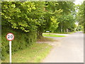
The Drive, Ifold
Scattered residential area in the Low Weald. Many of the homes are hidden by the greenery.
Image: © Colin Smith
Taken: 10 Sep 2011
0.12 miles
2
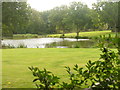
Loxwoodhills Pond
Artificial pond set within manicured grounds, east of Ifold.
Image: © Colin Smith
Taken: 10 Sep 2011
0.14 miles
4
River Arun by Loxwoodhills Lake
To the north of Ifold with giant hogweed growing on the riverbank.
http://www.weyandarun.co.uk/
Image: © Colin Smith
Taken: 10 Sep 2011
0.21 miles
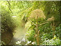
5
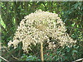
Giant Hogweed Lacecap
On the banks of the Arun by Loxwoodhills Pond. The lacecap is nearly 1 foot diameter and is on a stalk some 8 feet high.
http://www.weyandarun.co.uk/
Image: © Colin Smith
Taken: 10 Sep 2011
0.21 miles
6

Footpath and Bridleway Junction, Wey South Path
Image: © N Chadwick
Taken: 3 Apr 2011
0.22 miles

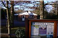
8
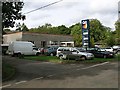
Former petrol station
Ifold Motors at the junction of Hogwood Road and The Lane, Loxwood. The Q8 filling station is now closed and it's only a used car and servicing garage. Given its location (well off the beaten track down a maze of rural residential roads) it's hard to imagine that it could have ever survived as a filling station. I'm guessing that it must date from when every village had a petrol station of some sort.
Image: © Andy Potter
Taken: 27 Sep 2006
0.24 miles

