IMAGES TAKEN NEAR TO
Plaistow, BILLINGSHURST, RH14 0PH
Introduction
This page details the photographs taken nearby to RH14 0PH by members of the Geograph project.
The Geograph project started in 2005 with the aim of publishing, organising and preserving representative images for every square kilometre of Great Britain, Ireland and the Isle of Man.

There are currently over 7.5m images from over14,400 individuals and you can help contribute to the project by visiting https://www.geograph.org.uk
Image Map
Images are licensed for reuse under creativecommons.org/licenses/by-sa/2.0
Notes
- Clicking on the map will re-center to the selected point.
- The higher the marker number, the further away the image location is from the centre of the postcode.
Image Listing (8 Images Found)
Images are licensed for reuse under creativecommons.org/licenses/by-sa/2.0
Image
Details
Distance
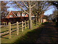
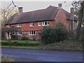
1
Lyons Green Cottages on Shillinglee Road
Image: © Dave Spicer
Taken: 13 Nov 2010
0.02 miles
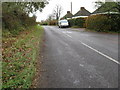
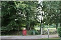
2

T-junction between Shillinglee Road on the left and Dunsfold Road
The entrance to Lyons Farm is by the signpost.
Image: © Dave Spicer
Taken: 13 Nov 2010
0.07 miles
3
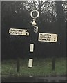
Old Direction Sign - Signpost by Dunsfold Road, Plaistow
Annulus finial - 3 arms; WSCC parish halo by the UC road, in parish of Plaistow (Chichester District), junction of Dunsfold Road with Shillinglee Road, on verge.
To be surveyed
Milestone Society National ID: SX_SU9931A
Image: © Milestone Society
Taken: Unknown
0.09 miles
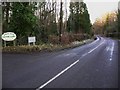
4
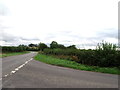
Dunsfold Road, near Plaistow, West Sussex
Image: © nick macneill
Taken: 7 Oct 2011
0.09 miles
6
Farm entrance on Dunsfold Road, Plaistow
Image: © David Howard
Taken: 13 Aug 2018
0.10 miles
7
Shillinglee Road looking west
The private road to Sparrwood Farm is to the left.
Image: © Shazz
Taken: 9 Jan 2011
0.15 miles