IMAGES TAKEN NEAR TO
Loxwood Road, BILLINGSHURST, RH14 0NY
Introduction
This page details the photographs taken nearby to Loxwood Road, RH14 0NY by members of the Geograph project.
The Geograph project started in 2005 with the aim of publishing, organising and preserving representative images for every square kilometre of Great Britain, Ireland and the Isle of Man.

There are currently over 7.5m images from over14,400 individuals and you can help contribute to the project by visiting https://www.geograph.org.uk
Image Map
Images are licensed for reuse under creativecommons.org/licenses/by-sa/2.0
Notes
- Clicking on the map will re-center to the selected point.
- The higher the marker number, the further away the image location is from the centre of the postcode.
Image Listing (9 Images Found)
Images are licensed for reuse under creativecommons.org/licenses/by-sa/2.0
Image
Details
Distance
1
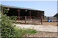
Charleshurst Farm
Barn opposite Charleshurst Farm on the Loxwood Road.
Image: © Ben Gamble
Taken: 17 Jul 2005
0.02 miles
2
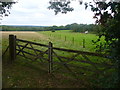
Weald Between Plaistow and Loxwood
Footpath following a fence line across a landscape of woodland mixed with grassy fields.
Image: © Colin Smith
Taken: 10 Sep 2011
0.08 miles
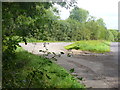
3
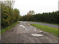
Lay-by on the Loxwood Road, halfway between Plaistow and Ifold
Image: © Dave Spicer
Taken: 13 Nov 2010
0.11 miles
5
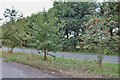
Loxwood Road Lay-by
On the Plaistow-Loxwood road, perhaps used by local farmers too.
Image: © Colin Smith
Taken: 10 Sep 2011
0.14 miles
6
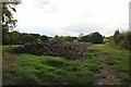
Dung!
A pile of Horse poo by Loxwood Road
Image: © David Howard
Taken: 13 Aug 2018
0.16 miles
7
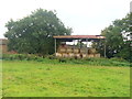
Charleshurst Farm
Early September and the straw bales are stacked up under cover in the open-sided barn.
Image: © Colin Smith
Taken: 10 Sep 2011
0.17 miles
9
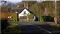
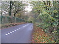
Junction of Loxwood and Plaistow Roads at Ifold
Image: © Shazz
Taken: 16 Nov 2009
0.23 miles