IMAGES TAKEN NEAR TO
Strood Green, BILLINGSHURST, RH14 0LH
Introduction
This page details the photographs taken nearby to Strood Green, RH14 0LH by members of the Geograph project.
The Geograph project started in 2005 with the aim of publishing, organising and preserving representative images for every square kilometre of Great Britain, Ireland and the Isle of Man.

There are currently over 7.5m images from over14,400 individuals and you can help contribute to the project by visiting https://www.geograph.org.uk
Image Map
Images are licensed for reuse under creativecommons.org/licenses/by-sa/2.0
Notes
- Clicking on the map will re-center to the selected point.
- The higher the marker number, the further away the image location is from the centre of the postcode.
Image Listing (7 Images Found)
Images are licensed for reuse under creativecommons.org/licenses/by-sa/2.0
Image
Details
Distance
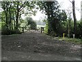
1
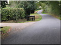
Milk churn stand outside Standgates Farm
Image: © Dave Spicer
Taken: 17 Oct 2009
0.03 miles
2
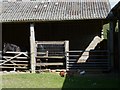
Farmyard north of Strood Green
The single pony is outnumbered by several types of bird.
Image: © Shazz
Taken: 4 May 2011
0.06 miles
3
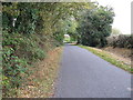
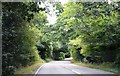
View south along narrow lane to Strood Green
Image: © Dave Spicer
Taken: 17 Oct 2009
0.12 miles
4
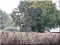
Top of the range tree house at Strood Green
Image: © Dave Spicer
Taken: 17 Oct 2009
0.21 miles
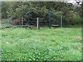
7
Footpath 3245 from Linfold Lane
This footpath runs almost death south to meet up with Linfold Lane again.
Image: © Andy Potter
Taken: 10 Oct 2006
0.25 miles