IMAGES TAKEN NEAR TO
Plaistow Road, BILLINGSHURST, RH14 0LB
Introduction
This page details the photographs taken nearby to Plaistow Road, RH14 0LB by members of the Geograph project.
The Geograph project started in 2005 with the aim of publishing, organising and preserving representative images for every square kilometre of Great Britain, Ireland and the Isle of Man.

There are currently over 7.5m images from over14,400 individuals and you can help contribute to the project by visiting https://www.geograph.org.uk
Image Map
Images are licensed for reuse under creativecommons.org/licenses/by-sa/2.0
Notes
- Clicking on the map will re-center to the selected point.
- The higher the marker number, the further away the image location is from the centre of the postcode.
Image Listing (7 Images Found)
Images are licensed for reuse under creativecommons.org/licenses/by-sa/2.0
Image
Details
Distance
2
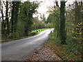
Bridge carrying Foxbridge Lane over a tributary of the River Arun
A couple of hundreds yards further south is Foxbridge Golf Club.
Image: © Dave Spicer
Taken: 13 Nov 2010
0.05 miles
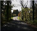
5
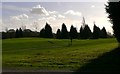
Foxbridge Golf Course
The farther part of the picture is in the next grid square to the south.
Image: © Shazz
Taken: 16 Nov 2009
0.09 miles
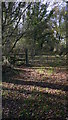
6
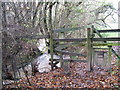
Stile and stream in close company
After heavy rain this stream was flowing fairly quickly. A few more years might see the stile losing its footing.
Image: © Dave Spicer
Taken: 13 Nov 2010
0.18 miles
7
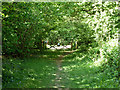
Path out of Corner Copse
A small Woodland Trust wood.
Image: © Robin Webster
Taken: 3 May 2011
0.23 miles