IMAGES TAKEN NEAR TO
Kirdford, BILLINGSHURST, RH14 0JW
Introduction
This page details the photographs taken nearby to RH14 0JW by members of the Geograph project.
The Geograph project started in 2005 with the aim of publishing, organising and preserving representative images for every square kilometre of Great Britain, Ireland and the Isle of Man.

There are currently over 7.5m images from over14,400 individuals and you can help contribute to the project by visiting https://www.geograph.org.uk
Image Map
Images are licensed for reuse under creativecommons.org/licenses/by-sa/2.0
Notes
- Clicking on the map will re-center to the selected point.
- The higher the marker number, the further away the image location is from the centre of the postcode.
Image Listing (14 Images Found)
Images are licensed for reuse under creativecommons.org/licenses/by-sa/2.0
Image
Details
Distance
1
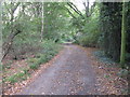
Restricted byway by Mackerel's Common
This byway connects Plaistow Road at Mackerel's Common to Plaistow nearly 3 kilometres to the north.
Image: © Dave Spicer
Taken: 16 Oct 2010
0.03 miles
2
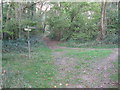
Byway junction
The two byways encompass Mackerel's Common.
Image: © Dave Spicer
Taken: 16 Oct 2010
0.15 miles
5
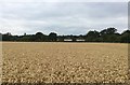
Houses at Mackerel?s Common
Looking across the field from the footpath at the houses beside the Plaistow Road.
Image: © Chris Thomas-Atkin
Taken: 20 Jul 2018
0.18 miles
6

Dogs on Mackerel's Common
These dogs did not find my presence welcome.
Image: © Shazz
Taken: 28 Jan 2011
0.19 miles
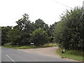
7

Mackerel's Common
The National Trust sign here uses the alternative spelling of "Mackrel's Common".
Image: © Shazz
Taken: 28 Jan 2011
0.20 miles
8
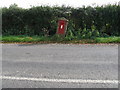
Weight restriction required for postbox RH14 65 at Mackerel's Common
Image: © Dave Spicer
Taken: 16 Oct 2010
0.21 miles

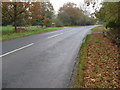
10
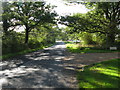
Plaistow Road approaching Mackerel's Common
Image: © Dave Spicer
Taken: 16 Oct 2010
0.21 miles