IMAGES TAKEN NEAR TO
Oakdene Place, BILLINGSHURST, RH14 0BA
Introduction
This page details the photographs taken nearby to Oakdene Place, RH14 0BA by members of the Geograph project.
The Geograph project started in 2005 with the aim of publishing, organising and preserving representative images for every square kilometre of Great Britain, Ireland and the Isle of Man.

There are currently over 7.5m images from over14,400 individuals and you can help contribute to the project by visiting https://www.geograph.org.uk
Image Map
Images are licensed for reuse under creativecommons.org/licenses/by-sa/2.0
Notes
- Clicking on the map will re-center to the selected point.
- The higher the marker number, the further away the image location is from the centre of the postcode.
Image Listing (18 Images Found)
Images are licensed for reuse under creativecommons.org/licenses/by-sa/2.0
Image
Details
Distance
1
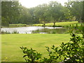
Loxwoodhills Pond
Artificial pond set within manicured grounds, east of Ifold.
Image: © Colin Smith
Taken: 10 Sep 2011
0.11 miles
2
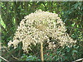
Giant Hogweed Lacecap
On the banks of the Arun by Loxwoodhills Pond. The lacecap is nearly 1 foot diameter and is on a stalk some 8 feet high.
http://www.weyandarun.co.uk/
Image: © Colin Smith
Taken: 10 Sep 2011
0.15 miles
3
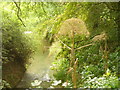
River Arun by Loxwoodhills Lake
To the north of Ifold with giant hogweed growing on the riverbank.
http://www.weyandarun.co.uk/
Image: © Colin Smith
Taken: 10 Sep 2011
0.15 miles
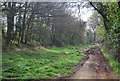


8

Footpath and Bridleway Junction, Wey South Path
Image: © N Chadwick
Taken: 3 Apr 2011
0.17 miles

10
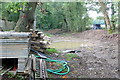
Below Southlands lock
This is an access point to canal work in the pound between Southlands lock (ahead) and Devil's Hole lock (half a mile behind us).
Image: © Graham Horn
Taken: 11 Sep 2010
0.19 miles