IMAGES TAKEN NEAR TO
Newpound, BILLINGSHURST, RH14 0AT
Introduction
This page details the photographs taken nearby to Newpound, RH14 0AT by members of the Geograph project.
The Geograph project started in 2005 with the aim of publishing, organising and preserving representative images for every square kilometre of Great Britain, Ireland and the Isle of Man.

There are currently over 7.5m images from over14,400 individuals and you can help contribute to the project by visiting https://www.geograph.org.uk
Image Map
Images are licensed for reuse under creativecommons.org/licenses/by-sa/2.0
Notes
- Clicking on the map will re-center to the selected point.
- The higher the marker number, the further away the image location is from the centre of the postcode.
Image Listing (8 Images Found)
Images are licensed for reuse under creativecommons.org/licenses/by-sa/2.0
Image
Details
Distance
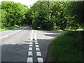
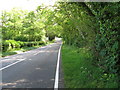
3
Durbans Road at the junction of Vicarage Hill
Image: © David Howard
Taken: 3 Aug 2015
0.12 miles
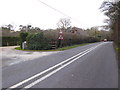
5
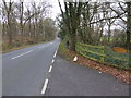
Looking along the B2133 from the entrance to Smale Farm
Image: © Shazz
Taken: 13 Dec 2015
0.15 miles
6
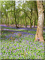
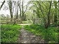
Smale Copse
Taken from the Wey-Arun Path which is also a bridleway at this point.
Image: © Simon Carey
Taken: 26 Apr 2008
0.22 miles
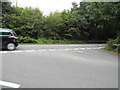
7
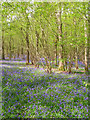
Sole Copse
Carpeted with bluebells in the central and eastern portion of the copse. Taken from the footpath that runs along the southern boundary.
Image: © Simon Carey
Taken: 26 Apr 2008
0.24 miles