IMAGES TAKEN NEAR TO
Walthurst Lane, BILLINGSHURST, RH14 0AD
Introduction
This page details the photographs taken nearby to Walthurst Lane, RH14 0AD by members of the Geograph project.
The Geograph project started in 2005 with the aim of publishing, organising and preserving representative images for every square kilometre of Great Britain, Ireland and the Isle of Man.

There are currently over 7.5m images from over14,400 individuals and you can help contribute to the project by visiting https://www.geograph.org.uk
Image Map
Images are licensed for reuse under creativecommons.org/licenses/by-sa/2.0
Notes
- Clicking on the map will re-center to the selected point.
- The higher the marker number, the further away the image location is from the centre of the postcode.
Image Listing (18 Images Found)
Images are licensed for reuse under creativecommons.org/licenses/by-sa/2.0
Image
Details
Distance
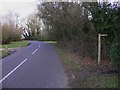
1
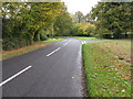
Gunshot Common
The road on the right leads to Wephurst Park
Image: © Dave Spicer
Taken: 31 Oct 2009
0.03 miles
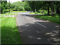
3
T-junction of the road to Wephurst Park and Skiff Lane
Image: © Dave Spicer
Taken: 16 Oct 2010
0.05 miles
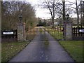
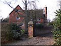
6
Trimmed trees at entrance to Pound House on Skiff lane
Image: © Dave Spicer
Taken: 16 Oct 2010
0.08 miles
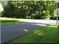
7
Bridleway leads off Skiff Lane on Gunshot Common
Image: © Shazz
Taken: 28 Jan 2011
0.09 miles
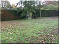
9
Private track to Skiff Lane on Gunshot Common
This photograph was taken from the bridleway.
Image: © Shazz
Taken: 28 Jan 2011
0.13 miles
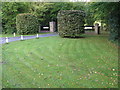
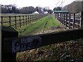
10

Sheep on Gunshot Common
This is a paddock attached to Pound House.
Image: © Shazz
Taken: 28 Jan 2011
0.15 miles