IMAGES TAKEN NEAR TO
Bletchingley Road, REDHILL, RH1 3PJ
Introduction
This page details the photographs taken nearby to Bletchingley Road, RH1 3PJ by members of the Geograph project.
The Geograph project started in 2005 with the aim of publishing, organising and preserving representative images for every square kilometre of Great Britain, Ireland and the Isle of Man.

There are currently over 7.5m images from over14,400 individuals and you can help contribute to the project by visiting https://www.geograph.org.uk
Image Map (Loading...)


Getting Data...Please wait
Leaflet Map data © OpenStreetMap
Images are licensed for reuse under creativecommons.org/licenses/by-sa/2.0
Notes
- Clicking on the map will re-center to the selected point.
- The higher the marker number, the further away the image location is from the centre of the postcode.
Image Listing (83 Images Found)
Images are licensed for reuse under creativecommons.org/licenses/by-sa/2.0
Image
Details
Distance
1
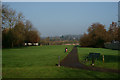
Recreation Ground, Merstham, Surrey
Looking towards the wooded North Downs.
Image: © Peter Trimming
Taken: 10 Dec 2013
0.04 miles
2
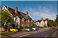
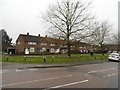
Bletchingley Road
Edwardian cottages on Bletchingley Road at its junction with Albury Road.
Image: © Ian Capper
Taken: 21 Apr 2012
0.04 miles
3
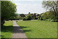
Brook Road Open Space
The southern end of a large area of open space retained between the houses.
Image: © Bill Boaden
Taken: 16 May 2019
0.05 miles
5
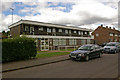
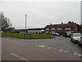
The Moat House Surgery
A doctor's practice originally founded in 1894.
Image: © Ian Capper
Taken: 19 Jun 2010
0.10 miles
6
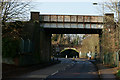
Railway Bridges at Merstham, Surrey
The railway lines from London to Brighton cross these two bridges. The original (distant) bridge carries the line which stops at Redhill, whilst the nearer bridge carries the 'avoiding' line, which passes under Redhill via a tunnel.
Image: © Peter Trimming
Taken: 10 Dec 2013
0.11 miles
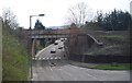
8
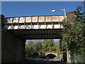
Railway bridges, Merstham
Two parallel lines, less than 50 metres apart, carrying branches of the Brighton line. The nearer carries the Quarry Line, used by through trains to Gatwick. The further bridge, shown in Image, serves Merstham and Redhill stations. In between the bridges is a mini-roundabout at the junction with Nutfield Road (left), which soon passes under the Quarry Line itself.
In spite of it being a beautifully sunny day, the street lamp is on.
Image: © Derek Harper
Taken: 15 Oct 2011
0.12 miles
10
Site of The Iron Horse
A former pub, demolished in March 2010. For photo of pub when in use see Image and for photo of pub after closure (and for background to the closure) see Image
Image: © Ian Capper
Taken: 19 Jun 2010
0.12 miles