IMAGES TAKEN NEAR TO
Radstock Way, REDHILL, RH1 3NG
Introduction
This page details the photographs taken nearby to Radstock Way, RH1 3NG by members of the Geograph project.
The Geograph project started in 2005 with the aim of publishing, organising and preserving representative images for every square kilometre of Great Britain, Ireland and the Isle of Man.

There are currently over 7.5m images from over14,400 individuals and you can help contribute to the project by visiting https://www.geograph.org.uk
Image Map
Images are licensed for reuse under creativecommons.org/licenses/by-sa/2.0
Notes
- Clicking on the map will re-center to the selected point.
- The higher the marker number, the further away the image location is from the centre of the postcode.
Image Listing (42 Images Found)
Images are licensed for reuse under creativecommons.org/licenses/by-sa/2.0
Image
Details
Distance
1
Wood carving - Furzefield Wood
This curious object was created in 2013 by the Tree Pirates - 'chainsaw artists' - as part of a Furzefield family fun day. It stands in the thin strip of woodland between Merstham's large housing estate and the M25.
Image: © Stephen McKay
Taken: 22 Nov 2017
0.07 miles
2
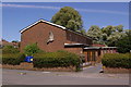
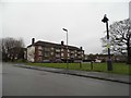
Church of the Epiphany
Built in 1955, serving the former 1950s London overspill estate in which it stands.
Postscript: The church closed for public worship in January 2015.
Image: © Ian Capper
Taken: 28 Jun 2008
0.10 miles
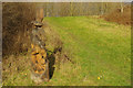
6
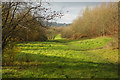
Furzefield Wood
Despite appearances this open area is sandwiched between Merstham's extensive LCC housing estate and the M25. The traffic roar is ever-present.
Image: © Stephen McKay
Taken: 22 Nov 2017
0.11 miles
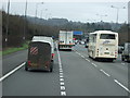
7
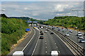
M25 at Merstham, looking west
The M23/M25 interchange is ahead. The footbridge viewpoint only affords a view in the direction of traffic if over one or other of the carriageways, as there are overhead gantry signs for each direction close to the bridge on either side.
Image: © Robin Webster
Taken: 5 Aug 2010
0.12 miles
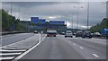
10
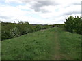
Tandridge Border Path beside the M25
This path leads from Image, along the top of a earthbund around Merstham.
It also leads to the remains of Furzefield Wood, which has the M25 running through it.
The border path leads towards Bletchingley Road.
Image: © David Anstiss
Taken: 16 May 2012
0.13 miles