IMAGES TAKEN NEAR TO
Warwick Wold Road, REDHILL, RH1 3DG
Introduction
This page details the photographs taken nearby to Warwick Wold Road, RH1 3DG by members of the Geograph project.
The Geograph project started in 2005 with the aim of publishing, organising and preserving representative images for every square kilometre of Great Britain, Ireland and the Isle of Man.

There are currently over 7.5m images from over14,400 individuals and you can help contribute to the project by visiting https://www.geograph.org.uk
Image Map
Images are licensed for reuse under creativecommons.org/licenses/by-sa/2.0
Notes
- Clicking on the map will re-center to the selected point.
- The higher the marker number, the further away the image location is from the centre of the postcode.
Image Listing (42 Images Found)
Images are licensed for reuse under creativecommons.org/licenses/by-sa/2.0
Image
Details
Distance
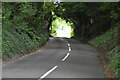
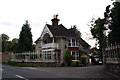
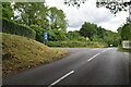
3
Warwick Wold Road at the junction of Rockshaw Road
Image: © David Howard
Taken: 29 Sep 2014
0.08 miles
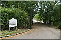
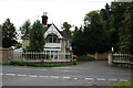
5
Merstham: Lodge and gates to Rockshaw House
Image: © Dr Neil Clifton
Taken: 16 Sep 2012
0.09 miles
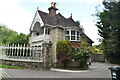
6
Merstham: Lodge and gates to Rockshaw House
Image: © Dr Neil Clifton
Taken: 16 Sep 2012
0.10 miles
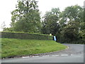
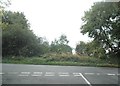
7
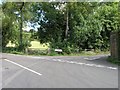
Countryside road junction near Chaldon
This junction is one of many on the narrow country roads that link this area. The road branching off is marked as Spring Bottom Lane.
Image: © Hywel Williams
Taken: 2 Sep 2005
0.10 miles
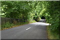
10
Spring Bottom Lane at the junction of Hilltop Lane
Image: © David Howard
Taken: 29 Sep 2014
0.13 miles