IMAGES TAKEN NEAR TO
London Road North, REDHILL, RH1 3BW
Introduction
This page details the photographs taken nearby to London Road North, RH1 3BW by members of the Geograph project.
The Geograph project started in 2005 with the aim of publishing, organising and preserving representative images for every square kilometre of Great Britain, Ireland and the Isle of Man.

There are currently over 7.5m images from over14,400 individuals and you can help contribute to the project by visiting https://www.geograph.org.uk
Image Map
Images are licensed for reuse under creativecommons.org/licenses/by-sa/2.0
Notes
- Clicking on the map will re-center to the selected point.
- The higher the marker number, the further away the image location is from the centre of the postcode.
Image Listing (40 Images Found)
Images are licensed for reuse under creativecommons.org/licenses/by-sa/2.0
Image
Details
Distance
1
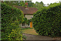
Weighbridge Cottage
Formerly the weighing and toll house for the Croydon, Merstham and Godstone Iron Railway.
The railway opened in 1805 as a southern extension of the 1803 Surrey Iron Railway, the first public railway in the world. Its purpose was to carry chalk and stone from Merstham Quarry, using horse drawn trucks. It was originally intended to continue to Godstone Green (hence Godstone in the name) and also Reigate, but these extensions never happened.
The cottage is grade II listed - for listing particulars see www.historicengland.org.uk/listing/the-list/list-entry/1029092.
Image: © Ian Capper
Taken: 25 Jul 2010
0.06 miles
2
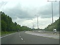
M23 Junction 7
Junction 7 is in fact the end of the M23. It was intended originally to extend the M23 further into London but the plans were never completed. Junction 7 was built with the extension in mind and so a vestigial "motorway" continues for about 500m after the junction peels off, ending in a bridge that was never used. Today, the road space where the motorway would have run is used by the motorway maintenance crew.
Image: © Hywel Williams
Taken: 1 Jul 2005
0.10 miles
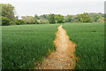
3

Footpath Through the Maize, Merstham, Surrey
Just like a jungle, with the maize reaching a height of 8 feet. At least, at this point, things other than dense foliage can be seen.
Image: © Peter Trimming
Taken: 13 Aug 2009
0.10 miles
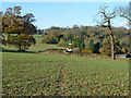
4

Stile View, Merstham, Surrey
The path emerges from the dense maize, crosses over the stile, dives into another maize field, passes to the left of the house in the middle distance, then to the right of the house in the far distance.
Image: © Peter Trimming
Taken: 13 Aug 2009
0.11 miles
5
Footpath Reigate 86
A muddy route in November, from Church Hill, Merstham to Harps Oak Lane.
Image: © Robin Webster
Taken: 16 Nov 2010
0.11 miles
6
Path near Church Hill
The farmer has done what is necessary to make sure the path is defined.
Image: © Bill Boaden
Taken: 17 May 2019
0.11 miles
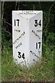
7
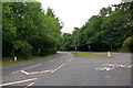
London Road North
Once the main road to Brighton, although now bypassed by the M23. Seen here at its junction with Harps Oak Lane. Note the milestone on the left - see Image for close-up.
Image: © Ian Capper
Taken: 25 Jul 2010
0.12 miles
8
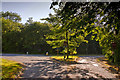
Harps Oak Lane
View from Harps Oak Lane looking towards the T-junction with the northbound section A23
Image: © Kurseong Carl
Taken: 21 May 2011
0.13 miles
10
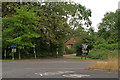
Harps Oak Lane
Harps Oak Lane at its junction with the A23 London Road North. In the background can be seen part of the grade II listed Hoath Farm Barn, dating from the 17th century - for listing particulars see www.historicengland.org.uk/listing/the-list/list-entry/1377972.
Image: © Ian Capper
Taken: 25 Jul 2010
0.13 miles