IMAGES TAKEN NEAR TO
Alderstead Lane, REDHILL, RH1 3AF
Introduction
This page details the photographs taken nearby to Alderstead Lane, RH1 3AF by members of the Geograph project.
The Geograph project started in 2005 with the aim of publishing, organising and preserving representative images for every square kilometre of Great Britain, Ireland and the Isle of Man.

There are currently over 7.5m images from over14,400 individuals and you can help contribute to the project by visiting https://www.geograph.org.uk
Image Map
Images are licensed for reuse under creativecommons.org/licenses/by-sa/2.0
Notes
- Clicking on the map will re-center to the selected point.
- The higher the marker number, the further away the image location is from the centre of the postcode.
Image Listing (12 Images Found)
Images are licensed for reuse under creativecommons.org/licenses/by-sa/2.0
Image
Details
Distance
1
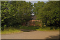
Outhouse
An outhouse on the Alderstead Lane
Image: © Kurseong Carl
Taken: 29 May 2011
0.04 miles
2
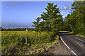
Alderstead Lane
Alderstead Lane before it becomes Shepherds Hill
Image: © Kurseong Carl
Taken: 29 May 2011
0.04 miles
3
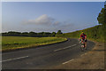
Weekend Cyclist
Cycling along the Alderstead Lane heading toward Merstham
Image: © Kurseong Carl
Taken: 29 May 2011
0.05 miles
4
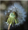
Puffball
Dandelion seeds in the field at Aldserstead Farm
Image: © Kurseong Carl
Taken: 26 Apr 2014
0.06 miles
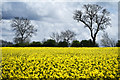
5

Rape
Rape growing in farmland adjoining Shepherds Hill
Image: © Kurseong Carl
Taken: 26 Apr 2014
0.08 miles
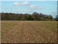
6
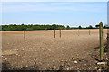
Footpath across a field
The beginning of the path has been slightly diverted, but the route is straight across the field. The field has been seeded and the path is not yet defined.
Image: © Bill Boaden
Taken: 15 May 2019
0.09 miles
7
Alderstead
Rape growing on farmland alongside Alderstead Lane
Image: © Kurseong Carl
Taken: 26 Apr 2014
0.10 miles
8
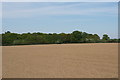
Footpath across a field
The path is currently not very clear, but one hopes it will become more so when the seeded crop comes up. I understand it will be sweetcorn.
Image: © Bill Boaden
Taken: 15 May 2019
0.16 miles
9
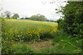
Oil seed rape on Shepherds Hill
A field on the escarpment of the North Downs.
Image: © Bill Boaden
Taken: 17 May 2019
0.17 miles
10
Footpath 99 (near) or 603 (far) towards Alderstead Heath
A lightly used, but well defined path cutting the corner of Alderstead and Green Lanes. It is odd that it is dual numbered on the Surrey map - all of it between roads should be in Merstham parish, the next parish boundary ahead being down the road.
Image: © Robin Webster
Taken: 3 Feb 2011
0.20 miles