IMAGES TAKEN NEAR TO
London Road North, REDHILL, RH1 3AA
Introduction
This page details the photographs taken nearby to London Road North, RH1 3AA by members of the Geograph project.
The Geograph project started in 2005 with the aim of publishing, organising and preserving representative images for every square kilometre of Great Britain, Ireland and the Isle of Man.

There are currently over 7.5m images from over14,400 individuals and you can help contribute to the project by visiting https://www.geograph.org.uk
Image Map (Loading...)


Getting Data...Please wait
Leaflet Map data © OpenStreetMap
Images are licensed for reuse under creativecommons.org/licenses/by-sa/2.0
Notes
- Clicking on the map will re-center to the selected point.
- The higher the marker number, the further away the image location is from the centre of the postcode.
Image Listing (12 Images Found)
Images are licensed for reuse under creativecommons.org/licenses/by-sa/2.0
Image
Details
Distance
1
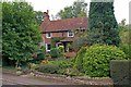
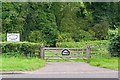
Fox Shaw
This 17th century cottage was formerly a pub, the Fox Inn, scene of a wager on 24 July 1805 between Edward Banks (contractor to the Croydon, Merstham and Godstone Railway), and local gentry as to the weight one horse could pull on the trial run of the railway, the route of which ran past the pub.
It is grade II listed - for listing particulars see www.historicengland.org.uk/listing/the-list/list-entry/1295170.
Image: © Ian Capper
Taken: 18 Sep 2010
0.06 miles
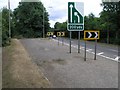
4
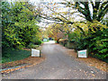
Hooley: Glebe Road
This small private road is off the west side of the A23.
Image: © Dr Neil Clifton
Taken: 17 Nov 2013
0.12 miles
5
The Iron Railway Vineyard
A small vineyard, in a sliver of land between the A23 and M23, just south of the northern terminus of the latter. It was originally planted in 1982 and 1983, and now contains vines of three varieties, Madeliene Angevine, Madeliene Sylvaner and Phoenix. Its name derives from its location on the route of the Croydon, Merstham and Godstone Iron Railway, opened in 1805 as a southern extension of the 1803 Surrey Iron Railway, the first public railway in the world. The purpose of the CM&GIR was to carry chalk and stone from Merstham Quarry, using horse drawn trucks, hence the sign on the gate.
Image: © Ian Capper
Taken: 18 Sep 2010
0.14 miles
6
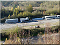
Stored crash barriers, M23
On the never completed extension northwards of the M23, concrete (?) interlocking sections to be used during road works.
Image: © Robin Webster
Taken: 16 Nov 2010
0.14 miles

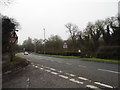
8
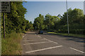
A23
View north of the A23 from the junction with Glebe Road
Image: © Kurseong Carl
Taken: 21 May 2011
0.17 miles
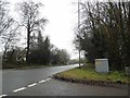
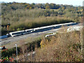
9
Uncompleted Motorway Junction
This is junction 7 on the M23 - and the end of the motorway as junctions 6 to 1 were never built. In the picture you can see the vestigial on-ramp which would have taken traffic in the London direction of the never completed motorway. The bridge in the distance is also part of the motorway and has never been used.
Image: © Hywel Williams
Taken: 1 Jul 2005
0.17 miles
10
Stored crash barriers, M23
On the never completed extension northwards of the M23, two sorts of crash barrier are stacked. On the left, prefabricated steel lengths, that appear of the permanent sort to be concreted in when in situ. On the right, concrete interlocking sections to be used during road works.
Image: © Robin Webster
Taken: 16 Nov 2010
0.20 miles