IMAGES TAKEN NEAR TO
Southwater Country Park, HORSHAM, RH13 9UN
Introduction
This page details the photographs taken nearby to Southwater Country Park, RH13 9UN by members of the Geograph project.
The Geograph project started in 2005 with the aim of publishing, organising and preserving representative images for every square kilometre of Great Britain, Ireland and the Isle of Man.

There are currently over 7.5m images from over14,400 individuals and you can help contribute to the project by visiting https://www.geograph.org.uk
Image Map
Images are licensed for reuse under creativecommons.org/licenses/by-sa/2.0
Notes
- Clicking on the map will re-center to the selected point.
- The higher the marker number, the further away the image location is from the centre of the postcode.
Image Listing (58 Images Found)
Images are licensed for reuse under creativecommons.org/licenses/by-sa/2.0
Image
Details
Distance
3
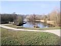
Lake in Southwater Country Park
viewed from the East
Image: © Paul Gillett
Taken: 4 Mar 2013
0.02 miles
5
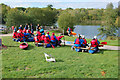
Raft class, Southwater Country Park
This looks like an intermediate stage between making the rafts and venturing with them onto the water.
Image: © Robin Webster
Taken: 22 Oct 2010
0.03 miles
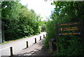
7
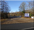
Entrance to Southwater Country Park on Cripplegate Lane
Image: © Shazz
Taken: 11 Dec 2016
0.03 miles
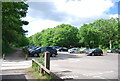
9
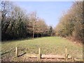
Trees by Southwater Country Park car park
Image: © Paul Gillett
Taken: 4 Mar 2013
0.03 miles
10
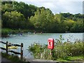
Cripplegate Lake, Southwater Country Park
Looking south from the visitor centre.
Image: © Janine Forbes
Taken: 1 Oct 2005
0.03 miles