IMAGES TAKEN NEAR TO
Marlpost Road, HORSHAM, RH13 9BY
Introduction
This page details the photographs taken nearby to Marlpost Road, RH13 9BY by members of the Geograph project.
The Geograph project started in 2005 with the aim of publishing, organising and preserving representative images for every square kilometre of Great Britain, Ireland and the Isle of Man.

There are currently over 7.5m images from over14,400 individuals and you can help contribute to the project by visiting https://www.geograph.org.uk
Image Map (Loading...)


Getting Data...Please wait
Leaflet Map data © OpenStreetMap
Images are licensed for reuse under creativecommons.org/licenses/by-sa/2.0
Notes
- Clicking on the map will re-center to the selected point.
- The higher the marker number, the further away the image location is from the centre of the postcode.
Image Listing (13 Images Found)
Images are licensed for reuse under creativecommons.org/licenses/by-sa/2.0
Image
Details
Distance
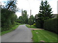
1
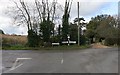
Road Junction
Church Lane and Marlpost Road.
Image: © The Saunterer
Taken: 8 Nov 2012
0.06 miles
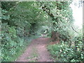
3
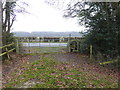
Looking across corner of field from Marlpost Road
A footpath junction is seen just ahead.
Image: © Shazz
Taken: 16 Dec 2016
0.09 miles
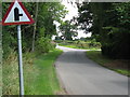
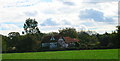
4
Lane heading NE towards Two Mile Ash
Marlpost Farm on the right
Image: © Dave Spicer
Taken: 25 Jul 2009
0.11 miles
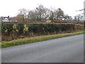
5
Swains, Marlpost Road, near Southwater
18th century house near Southwater. This view looks south from Marlpost Road.
Image: © Simon Carey
Taken: 22 Oct 2005
0.11 miles
6
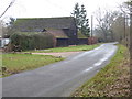
Marlpost Farm
For a view the other way in 2009 see http://www.geograph.org.uk/photo/1417420.
Image: © Shazz
Taken: 16 Dec 2016
0.12 miles
8
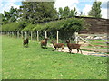
Castle Moorit sheep on footpath to Marlpost Farm
Image: © Dave Spicer
Taken: 25 Jul 2009
0.13 miles