IMAGES TAKEN NEAR TO
Southwater Street, HORSHAM, RH13 9BN
Introduction
This page details the photographs taken nearby to Southwater Street, RH13 9BN by members of the Geograph project.
The Geograph project started in 2005 with the aim of publishing, organising and preserving representative images for every square kilometre of Great Britain, Ireland and the Isle of Man.

There are currently over 7.5m images from over14,400 individuals and you can help contribute to the project by visiting https://www.geograph.org.uk
Image Map (Loading...)


Getting Data...Please wait
Leaflet Map data © OpenStreetMap
Images are licensed for reuse under creativecommons.org/licenses/by-sa/2.0
Notes
- Clicking on the map will re-center to the selected point.
- The higher the marker number, the further away the image location is from the centre of the postcode.
Image Listing (23 Images Found)
Images are licensed for reuse under creativecommons.org/licenses/by-sa/2.0
Image
Details
Distance
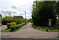
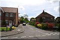
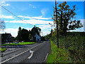
6
Southwater Street
Once a separate community, Southwater Street has been swallowed up by Southwater. This view looks east.
Image: © Simon Carey
Taken: 22 Oct 2005
0.09 miles

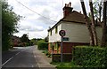
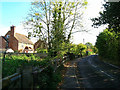
10
Worthing Road, Southwater
Once the main A24 this road has had its traffic reduced significantly by the bypass. This view looks south past the pub called the Hen & Chicken.
Image: © Simon Carey
Taken: 22 Oct 2005
0.14 miles