IMAGES TAKEN NEAR TO
Potters Green, Station Road, HORSHAM, RH13 8QZ
Introduction
This page details the photographs taken nearby to Potters Green, Station Road, RH13 8QZ by members of the Geograph project.
The Geograph project started in 2005 with the aim of publishing, organising and preserving representative images for every square kilometre of Great Britain, Ireland and the Isle of Man.

There are currently over 7.5m images from over14,400 individuals and you can help contribute to the project by visiting https://www.geograph.org.uk
Image Map
Images are licensed for reuse under creativecommons.org/licenses/by-sa/2.0
Notes
- Clicking on the map will re-center to the selected point.
- The higher the marker number, the further away the image location is from the centre of the postcode.
Image Listing (199 Images Found)
Images are licensed for reuse under creativecommons.org/licenses/by-sa/2.0
Image
Details
Distance
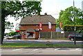
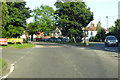
1
Potters Green
Small cul-de-sac off Station Road, the A272, that leads to St Peter's primary school. The shop on the right sells blinds and is one of about ten that exist in this small village.
Image: © Simon Carey
Taken: 24 Aug 2010
0.01 miles


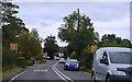
4
A272 entering Cowfold from the west
The A272 has a joggled crossing with the A281 in the village.
Image: © Robin Webster
Taken: 27 Jun 2019
0.03 miles

6
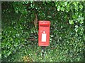
Post Box
Post Box RH13 214. Tower Hill. Horsham.
Image: © The Saunterer
Taken: 18 Jul 2012
0.03 miles