IMAGES TAKEN NEAR TO
Coolham, HORSHAM, RH13 8QQ
Introduction
This page details the photographs taken nearby to RH13 8QQ by members of the Geograph project.
The Geograph project started in 2005 with the aim of publishing, organising and preserving representative images for every square kilometre of Great Britain, Ireland and the Isle of Man.

There are currently over 7.5m images from over14,400 individuals and you can help contribute to the project by visiting https://www.geograph.org.uk
Image Map
Images are licensed for reuse under creativecommons.org/licenses/by-sa/2.0
Notes
- Clicking on the map will re-center to the selected point.
- The higher the marker number, the further away the image location is from the centre of the postcode.
Image Listing (6 Images Found)
Images are licensed for reuse under creativecommons.org/licenses/by-sa/2.0
Image
Details
Distance
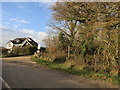
1
The house at Juniper Farm
The footpath turns right off the drive at this point.
Image: © Shazz
Taken: 18 Aug 2016
0.05 miles
2
The drive to Juniper Farm
See also http://www.geograph.org.uk/photo/1689127.
Image: © Shazz
Taken: 18 Aug 2016
0.19 miles
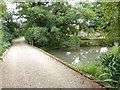
3

Farm road to Barnhouse Farm
Although this is also a footpath, the WSCC have it as an unavailable path. Due to buildings and a pond on the legal line
Image: © Dave Spicer
Taken: 31 Jan 2010
0.19 miles
4
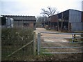
Horses in Shed
Jenden's Farm buildings from Public bridleway BW1966
Image: © The Saunterer
Taken: 24 Feb 2013
0.23 miles
5
Public Bridleway BW1966
Off Countryman lane at Jenden's Farm Cottages
Image: © The Saunterer
Taken: 2 Dec 2012
0.24 miles
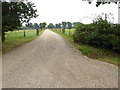
6
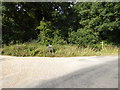
Junction on Countryman Lane
Next to each other are a drive to four signposted properties and a public bridleway.
Image: © Shazz
Taken: 18 Aug 2016
0.24 miles