IMAGES TAKEN NEAR TO
Coolham Road, HORSHAM, RH13 8PF
Introduction
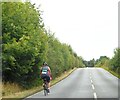
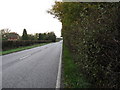
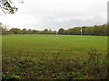
This page details the photographs taken nearby to Coolham Road, RH13 8PF by members of the Geograph project.
The Geograph project started in 2005 with the aim of publishing, organising and preserving representative images for every square kilometre of Great Britain, Ireland and the Isle of Man.

There are currently over 7.5m images from over14,400 individuals and you can help contribute to the project by visiting https://www.geograph.org.uk
Image Map
Images are licensed for reuse under creativecommons.org/licenses/by-sa/2.0
Notes
- Clicking on the map will re-center to the selected point.
- The higher the marker number, the further away the image location is from the centre of the postcode.
Image Listing (8 Images Found)
Images are licensed for reuse under creativecommons.org/licenses/by-sa/2.0
Image
Details
Distance
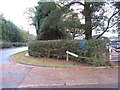
4
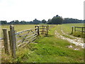
Parting of the ways
The footpath south from the A272 turns left through the gate and ahead is a private track.
Image: © Shazz
Taken: 18 Aug 2016
0.13 miles