IMAGES TAKEN NEAR TO
Worthing Road, HORSHAM, RH13 8NQ
Introduction
This page details the photographs taken nearby to Worthing Road, RH13 8NQ by members of the Geograph project.
The Geograph project started in 2005 with the aim of publishing, organising and preserving representative images for every square kilometre of Great Britain, Ireland and the Isle of Man.

There are currently over 7.5m images from over14,400 individuals and you can help contribute to the project by visiting https://www.geograph.org.uk
Image Map
Images are licensed for reuse under creativecommons.org/licenses/by-sa/2.0
Notes
- Clicking on the map will re-center to the selected point.
- The higher the marker number, the further away the image location is from the centre of the postcode.
Image Listing (56 Images Found)
Images are licensed for reuse under creativecommons.org/licenses/by-sa/2.0
Image
Details
Distance
1
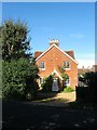
School Cottages, Worthing Road, Dial Post
The eastern side of Image and numbered 97 thus belonging or once belonged to the Knepp Estate. Built in the mid 19th century originally as three small cottages that were converted into the current pair in the mid 1960s.
Image: © Simon Carey
Taken: 23 Sep 2016
0.01 miles
2
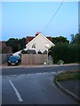
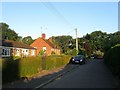
School House, Swallows Lane, Dial Post
Possibly used as the school master's house for the former Dial Post school which was located across the road out of shot to the right that had opened as a National School in 1864 and closed in 1966 and demolished soon after. Viewed at dusk.
Image: © Simon Carey
Taken: 26 Aug 2016
0.01 miles
3
Shirley Cottage, Worthing Road, Dial Post
Originally a pair of dwellings known as Lakers Cottages that have been converted into a single residence. To the right is the junction with Swallows Lane.
Image: © Simon Carey
Taken: 23 Sep 2016
0.02 miles
4
5-6, Swallows Lane, Dial Post
The semi-detached bungalows were built in the late 1960s on the site of Dial Post School. Opened in 1864 as a National School numbers were never high and had been reduced to sixteen by the time it closed in 1966.
Image: © Simon Carey
Taken: 23 Sep 2016
0.03 miles
5
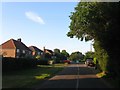
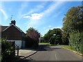
Swallows Lane, Dial Post
The view as you enter Dial Post from the north west. On the left are numbers 1-4 that were built in the late 1940s. The road was originally the B2224 that ran north to Southwater crossing the A272 near Dragons Green. It was declassified in the late 1980s when the A24 by-passes for Southwater and Dial Post was built.
Image: © Simon Carey
Taken: 23 Jul 2016
0.03 miles
6
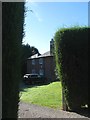
New Lodge, Worthing Road, Dial Post
The white square visible between the two windows on the right is a plaque that gives the date 1735 though it appears the exterior was remodelled in the early 18th century. Located on the northern side of Dial Post.
Image: © Simon Carey
Taken: 23 Sep 2016
0.04 miles
7
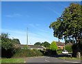
Swallows Lane, Dial Post
A small cul de sac off the main Swallows Lane contains numbers 7-12. The semi-detached cottages, numbers 9-12, were built in the 1950s whilst the semi-detached bungalows, numbers 7-8, were added in the late 1960s on the site of Dial Post's former school.
Image: © Simon Carey
Taken: 23 Jul 2016
0.05 miles
8

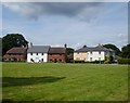
1-3, The Green, Dial Post
Built around 2000 the cul de sac consists of 10 large houses that sit around the edge of an open space. Numbers 1-3 are on the northern side, see also Image
Image: © Simon Carey
Taken: 23 Jul 2016
0.05 miles
10
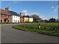
The Green at Dial Post
Incidentally the road is called The Green
Image: © Dave Spicer
Taken: 11 Feb 2009
0.05 miles