IMAGES TAKEN NEAR TO
Butchers Row, HORSHAM, RH13 8NF
Introduction
This page details the photographs taken nearby to Butchers Row, RH13 8NF by members of the Geograph project.
The Geograph project started in 2005 with the aim of publishing, organising and preserving representative images for every square kilometre of Great Britain, Ireland and the Isle of Man.

There are currently over 7.5m images from over14,400 individuals and you can help contribute to the project by visiting https://www.geograph.org.uk
Image Map (Loading...)


Getting Data...Please wait
Leaflet Map data © OpenStreetMap
Images are licensed for reuse under creativecommons.org/licenses/by-sa/2.0
Notes
- Clicking on the map will re-center to the selected point.
- The higher the marker number, the further away the image location is from the centre of the postcode.
Image Listing (122 Images Found)
Images are licensed for reuse under creativecommons.org/licenses/by-sa/2.0
Image
Details
Distance
1
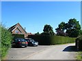
1-2, Butcher's Row, West Grinstead
A pair of dwellings built between the wars. Butcher's Row is the name given to the small collection of cottages south of the River Adur.
Image: © Simon Carey
Taken: 19 Jul 2016
0.00 miles
2
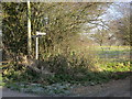
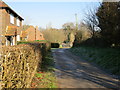
Public Footpath FP1855
Joins Public Footpath FP1845
Image: © The Saunterer
Taken: 11 Dec 2012
0.02 miles
3
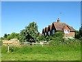
Kings Cottage, Butcher's Row, West Grinstead
Dating from the 19th century and originally two dwellings. Beyond is Image
Image: © Simon Carey
Taken: 19 Jul 2016
0.02 miles
4
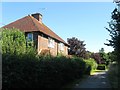
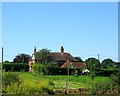
Fosters Farmhouse, Butcher's Row
Parts date from the 17th century and the building is the oldest in this small hamlet.
Image: © Simon Carey
Taken: 22 Nov 2008
0.02 miles
5
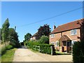
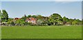
Fosters Farm, West Grinstead
Viewed from north of the River Adur. The farmhouse dates back to the 16th century and for many years was part of the West Grinstead Park Estate.
Image: © Simon Carey
Taken: 19 Jul 2016
0.04 miles
6
Fosters Farm Cottages, Butcher's Row, West Grinstead
Built in the late 19th century and sometimes known as plain Fosters Cottages. The cottages overlook Image to the east.
Image: © Simon Carey
Taken: 19 Jul 2016
0.04 miles
7
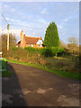
Houses at Butcher's Row
I am taking 'Butcher's Row' to be the name for the cluster of houses hereabouts - based on my interpretation of the OS map. However it could be that 'Butcher's Row' refers to a specific row of houses. Local knowledge is needed!
Image: © Ian Hawfinch
Taken: 23 Apr 2020
0.04 miles
9
Fosters Barn, Butchers Row, West Grinstead
Former outbuilding of Image that was converted into a dwelling during the mid 1990s.
Image: © Simon Carey
Taken: 9 Aug 2016
0.04 miles
10
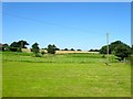
Clothalls Small Plat
The name of the field according to West Grinstead's 1841 tithe map that is bounded by Image to the south and Image to the north.
Image: © Simon Carey
Taken: 19 Jul 2016
0.05 miles