IMAGES TAKEN NEAR TO
Meyers Wood, HORSHAM, RH13 8JN
Introduction
This page details the photographs taken nearby to Meyers Wood, RH13 8JN by members of the Geograph project.
The Geograph project started in 2005 with the aim of publishing, organising and preserving representative images for every square kilometre of Great Britain, Ireland and the Isle of Man.

There are currently over 7.5m images from over14,400 individuals and you can help contribute to the project by visiting https://www.geograph.org.uk
Image Map (Loading...)


Getting Data...Please wait
Leaflet Map data © OpenStreetMap
Images are licensed for reuse under creativecommons.org/licenses/by-sa/2.0
Notes
- Clicking on the map will re-center to the selected point.
- The higher the marker number, the further away the image location is from the centre of the postcode.
Image Listing (178 Images Found)
Images are licensed for reuse under creativecommons.org/licenses/by-sa/2.0
Image
Details
Distance
1
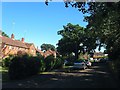
Meyers Wood, Partridge Green
A cul de sac off High Street named after a former wood that numbers 1-16 on the left along with neighbouring Huffwood Trading Estate were constructed on. The road itself is the former access road for Partridge Green station which opened in 1861 and closed in 1966. Numbers 1-16 were built in the 1950s whilst 17-18 out of shot to the right of the white van in the distance were added in the early 1970s on the eastern side of the bridge that carried the B2135 over the line. Numbers 20-29 were added in the late 1970s with 20-23, visible in the distance, built on the site of the former station house.
Image: © Simon Carey
Taken: 6 Aug 2016
0.03 miles
2
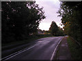
Former Railway Bridge, Bines Road
Built in 1860 to carry what is now the B2135 over the newly opened Horsham to Shoreham branch. Partridge Green station was sited below the bridge to the left until its closure in 1966 where it has since been demolished and replaced by housing and an industrial estate. The Downslink long distance bridleway briefly follows the road to the south before rejoining the route of the former railway. Taken twelve minutes before sunrise.
Image: © Simon Carey
Taken: 2 Oct 2010
0.04 miles
3
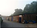
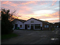
Units 21-26, Huffwood Trading Estate, Partridge Green
The small trading estate is located off the High Street and was originally the site of Meyer's Wood. Still a wood on a 1946 aerial photograph it was grubbed soon after in order to build an egg packing facility. This continued in operation until 1970 after which the buildings were converted into small business units primarily for new start ups. There are currently 32 units on the estate though some have been combined. At the time of writing Units 21-24 were occupied by a bespoke furniture upholsterer and Unit 25 by a firm dealing in cash registers.
Viewed on a morning when Partridge Green was shrouded in fog.
Image: © Simon Carey
Taken: 23 Sep 2016
0.04 miles
4

Units 4a, 5 and 6, Huffwood Trading Estate, Partridge Green
The small trading estate is located off the High Street and was originally the site of Meyer's Wood. Still a wood on a 1946 aerial photograph it was grubbed soon after in order to build an egg packing facility. This continued in operation until 1970 after which the buildings were converted into small business units primarily for new start ups. There are currently 32 units on the estate though some have been combined.
Image: © Simon Carey
Taken: 23 Sep 2016
0.05 miles
5
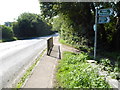
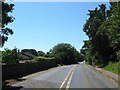
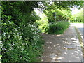
The B2135 looking south from bridleway junction
The bridleway is used by the Downs Link path. A view the other way from 2009 is at http://www.geograph.org.uk/photo/1297080.
Image: © Shazz
Taken: 10 Sep 2015
0.05 miles
6
Bines Road, Partridge Green
The B2135 heading south over the old railway bridge. On the left is the southern tip of Meiers Wood a housing estate built at the western edge of the site of the former station. To the right is the entrance to the Downs Link which returns to the track having detoured around the former station site which is now an industrial estate.
Image: © Simon Carey
Taken: 19 Jul 2016
0.05 miles
7
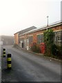
Huffwood Trading Estate
To the south of the High Street, the site was originally occupied by brickmakers until the early 20th century. Post 1945 this was an egg packing station that utilised goods facilities at nearby Partridge Green station. The egg packing survived the line by eight years before closing in 1974 to be replaced by small industrial units.
Image: © Simon Carey
Taken: 22 Nov 2008
0.05 miles
9
Units 4 and 7, Huffwood Trading Estate, Partridge Green
The small trading estate is located off the High Street and was originally the site of Meyer's Wood. Still a wood on a 1946 aerial photograph it was grubbed soon after in order to build an egg packing facility. This continued in operation until 1970 after which the buildings were converted into small business units primarily for new start ups. There are currently 32 units on the estate though some have been combined. At the time of writing unit 4 was occupied by Set Productions Ltd who also used Unit 4a on the western side, see Image
Much of Partridge Green was shrouded in fog on this morning.
Image: © Simon Carey
Taken: 23 Sep 2016
0.06 miles
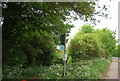
10
Junction of the Downs Link trail with the B2135
Image: © Dave Spicer
Taken: 9 May 2009
0.06 miles