IMAGES TAKEN NEAR TO
Littleworth Lane, HORSHAM, RH13 8JF
Introduction
This page details the photographs taken nearby to Littleworth Lane, RH13 8JF by members of the Geograph project.
The Geograph project started in 2005 with the aim of publishing, organising and preserving representative images for every square kilometre of Great Britain, Ireland and the Isle of Man.

There are currently over 7.5m images from over14,400 individuals and you can help contribute to the project by visiting https://www.geograph.org.uk
Image Map (Loading...)


Getting Data...Please wait
Leaflet Map data © OpenStreetMap
Images are licensed for reuse under creativecommons.org/licenses/by-sa/2.0
Notes
- Clicking on the map will re-center to the selected point.
- The higher the marker number, the further away the image location is from the centre of the postcode.
Image Listing (83 Images Found)
Images are licensed for reuse under creativecommons.org/licenses/by-sa/2.0
Image
Details
Distance
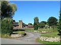
1
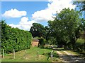
Limekiln Lane, Littleworth
The name given to the track on West Grinstead's 1841 tithe map which originally provided access to Image Now a private track.
Image: © Simon Carey
Taken: 31 Jul 2016
0.01 miles
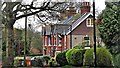
2
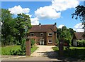
Oakfield, Littleworth Lane, Littleworth
A house on the eastern side of Littleworth Lane built between the wars on a former field called Hovel Plat, according to West Grinstead's 1841 tithe map.
Image: © Simon Carey
Taken: 31 Jul 2016
0.03 miles
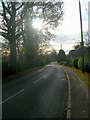
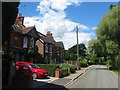
3
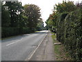
View south along Littleworth Lane towards Partridge Green
Image: © Dave Spicer
Taken: 19 Sep 2009
0.03 miles
4
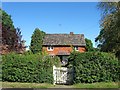
Haynes, Littleworth Lane, Littleworth
A former farmhouse dating back to the 17th century
Image: © Simon Carey
Taken: 23 Aug 2016
0.04 miles
5
Rickmans, Littleworth Lane, Littleworth
A bungalow at the south eastern end of the settlement of Littleworth that was built in the early 1970s.
Image: © Simon Carey
Taken: 23 Aug 2016
0.04 miles
6
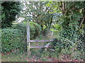
Footpath FP1839
Off Littleworth Lane.
Image: © The Saunterer
Taken: 12 Oct 2012
0.05 miles
7
Littleworth Lane
At the southern end of the hamlet of Littleworth travelling back towards Partridge Green. Once the eastern boundary of Jolesfield Common.
Image: © Simon Carey
Taken: 22 Nov 2008
0.06 miles
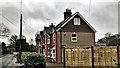
10
Cottages, Littleworth Lane, Littleworth
On the left are Fernhill and Ferncote built in 1911 with Fairview and longland beyond erected in 1908.
Image: © Simon Carey
Taken: 31 Jul 2016
0.07 miles