IMAGES TAKEN NEAR TO
Hunters Mead, HORSHAM, RH13 8HS
Introduction
This page details the photographs taken nearby to Hunters Mead, RH13 8HS by members of the Geograph project.
The Geograph project started in 2005 with the aim of publishing, organising and preserving representative images for every square kilometre of Great Britain, Ireland and the Isle of Man.

There are currently over 7.5m images from over14,400 individuals and you can help contribute to the project by visiting https://www.geograph.org.uk
Image Map
Images are licensed for reuse under creativecommons.org/licenses/by-sa/2.0
Notes
- Clicking on the map will re-center to the selected point.
- The higher the marker number, the further away the image location is from the centre of the postcode.
Image Listing (194 Images Found)
Images are licensed for reuse under creativecommons.org/licenses/by-sa/2.0
Image
Details
Distance
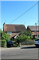
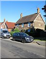
1
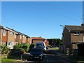
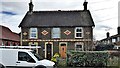
Hunters Mead, Partridge Green
A cul de sac off High Street built in the mid 1960s.
Image: © Simon Carey
Taken: 6 Aug 2016
0.01 miles
2
Eglantine Cottages, High Street, Partridge Green
A small terrace of three 19th century cottages on the southern side of the High Street.
Image: © Simon Carey
Taken: 6 Aug 2016
0.02 miles
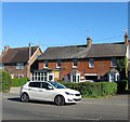
3
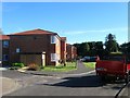
Pretty Court, Hunters Mead, Partridge Green
A recent development in the cul de sac off High Street that was completed in 2015 containing a block of flats and three individual houses. These replaced Peacocks, a sheltered accommodation block.
Image: © Simon Carey
Taken: 11 Sep 2016
0.02 miles
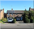
4
Laurel Cottages, High Street, Partridge Green
A semi-detached pair of cottages on the southern side of the High Street that date from the 19th century.
Image: © Simon Carey
Taken: 6 Aug 2016
0.02 miles
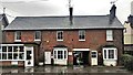
5
Prospect House/The Old Bakehouse, High Street, Partridge Green
Built in the late 19th century probably as three cottage. Prospect House is on the right and is a private dwelling whilst the rest of the building is taken up by The Old Bakehouse, originally the village bakery, but since the mid 1990s a veterinary surgery.
Image: © Simon Carey
Taken: 6 Aug 2016
0.03 miles
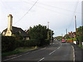
6
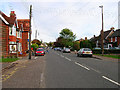
High Street, Partridge Green
The B2116 looking east. The Post Office is to the left of the parked red car.
Image: © Simon Carey
Taken: 22 Oct 2005
0.03 miles
7
Hawthorn Veterinary Surgery, Partridge Green
Image: © Ian Hawfinch
Taken: 24 Feb 2020
0.03 miles
8
Oxford Cottage/Cambridge House, High Street, Partridge Green
A semi-detached pair of cottages built in the late 19th century on the site of Pike Field, according to West Grinstead's 1841 tithe map.
Image: © Simon Carey
Taken: 6 Aug 2016
0.03 miles
9
High Street
The eastern end of Partridge Green's high street which begins at this point and ends at the junction with the B2135 which can just be seen in the distance. The building with the big chimney on the left is Deans Cottage.
Image: © Simon Carey
Taken: 2 Oct 2010
0.04 miles