IMAGES TAKEN NEAR TO
High Street, HORSHAM, RH13 8HR
Introduction
This page details the photographs taken nearby to High Street, RH13 8HR by members of the Geograph project.
The Geograph project started in 2005 with the aim of publishing, organising and preserving representative images for every square kilometre of Great Britain, Ireland and the Isle of Man.

There are currently over 7.5m images from over14,400 individuals and you can help contribute to the project by visiting https://www.geograph.org.uk
Image Map (Loading...)


Getting Data...Please wait
Leaflet Map data © OpenStreetMap
Images are licensed for reuse under creativecommons.org/licenses/by-sa/2.0
Notes
- Clicking on the map will re-center to the selected point.
- The higher the marker number, the further away the image location is from the centre of the postcode.
Image Listing (207 Images Found)
Images are licensed for reuse under creativecommons.org/licenses/by-sa/2.0
Image
Details
Distance
1
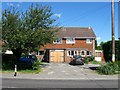
Lee Acre/The Old Telephone Exchange, High Street, Partridge Green
Built on the site of the original telephone exchange until it moved to a new premises in Finches close, see Image, sometime in the late 1960s. Lee Acre is on the left with the garage.
Image: © Simon Carey
Taken: 31 Jul 2016
0.01 miles
2

Orchard Villa/Lynwood, High Street, Partridge Green
A semi-detached pair of houses built between the wars. Orchard Villa is on the left, Lynwood to the right.
Image: © Simon Carey
Taken: 31 Jul 2016
0.01 miles
3

Tumblers/Rocheath, High Street, Partridge Green
A semi-detached pair of houses built sometime in the 1960s or 70s. Tumblers is on the left and Rocheath to the right.
Image: © Simon Carey
Taken: 31 Jul 2016
0.01 miles
4
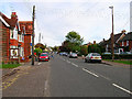
High Street, Partridge Green
The B2116 looking east. The Post Office is to the left of the parked red car.
Image: © Simon Carey
Taken: 22 Oct 2005
0.01 miles
5

Hydon House, High Street, Partridge Green
A single house that I think dates from either the 1960s or 70s.
Image: © Simon Carey
Taken: 31 Jul 2016
0.02 miles
6
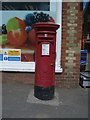
Post Box
Post Box RH12 148 High Street Stores & Post Office. Situated outside convenience stores in High Street near to Fire Station.
Image: © The Saunterer
Taken: 22 Apr 2012
0.02 miles
7

The Co-Operative, High Street, Partridge Green
The main village store which also contains the Post Office whose original site was at the junction with South Street. The building dates from the first decade of the 20th century and includes Image to the west.
Image: © Simon Carey
Taken: 31 Jul 2016
0.02 miles
8

Woodlawn, High Street, Partridge Green
An Edwardian house that also includes Image to the east. This part contains a doctors surgery and flats.
Image: © Simon Carey
Taken: 31 Jul 2016
0.03 miles
9

Nortonville, High Street, Partridge Green
A single dwelling dating from the Edwardian period.
Image: © Simon Carey
Taken: 31 Jul 2016
0.03 miles
10
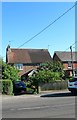
Laurel Cottages, High Street, Partridge Green
A semi-detached pair of cottages on the southern side of the High Street that date from the 19th century.
Image: © Simon Carey
Taken: 6 Aug 2016
0.03 miles