IMAGES TAKEN NEAR TO
Hazelwood Road, HORSHAM, RH13 8EX
Introduction
This page details the photographs taken nearby to Hazelwood Road, RH13 8EX by members of the Geograph project.
The Geograph project started in 2005 with the aim of publishing, organising and preserving representative images for every square kilometre of Great Britain, Ireland and the Isle of Man.

There are currently over 7.5m images from over14,400 individuals and you can help contribute to the project by visiting https://www.geograph.org.uk
Image Map
Images are licensed for reuse under creativecommons.org/licenses/by-sa/2.0
Notes
- Clicking on the map will re-center to the selected point.
- The higher the marker number, the further away the image location is from the centre of the postcode.
Image Listing (136 Images Found)
Images are licensed for reuse under creativecommons.org/licenses/by-sa/2.0
Image
Details
Distance
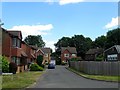
1
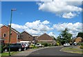
Hazelwood Road, Partridge Green
A cul de sac that runs east then south of South Street. The estate was built in the 1970s on the site of Kensett's Brickworks which operated here from the 1880s until the 1920s with this section having previously been a field called Little Two Acres according to West Grinstead's 1841 tithe map.
Image: © Simon Carey
Taken: 31 Jul 2016
0.01 miles
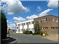
2
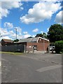
Telephone Exchange, Finches Close, Partridge Green
Built with the estate in the 1970s replacing the former exchange on High Street, see Image
Image: © Simon Carey
Taken: 31 Jul 2016
0.04 miles
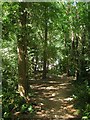
3
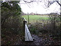
Footpath over bridge towards the edge of housing at Partridge Green
Image: © Shazz
Taken: 11 Jan 2017
0.04 miles
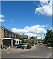
4
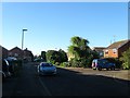
South Street, Partridge Green
A view of the southern extension of Image that was constructed as part of an estate that included Image and Image on the site of Kensetts Brickworks which operated here from the 1880s to 1920s. To the south is Image
Image: © Simon Carey
Taken: 6 Aug 2016
0.04 miles
5
Little Finches, Partridge Green
A cul de sac off Finches Close that was built in the late 1980s on the site of the former Kensett's Brickworks which operated here from the 1880s until the 1920s. Previously it had been a field called Long Two Acres according to West Grinstead's 1841 tithe map. To the right is Image
Image: © Simon Carey
Taken: 9 Aug 2016
0.05 miles
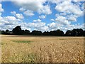
6
Ash Wood
A small wood located to the immediate south of Partridge Green. Not marked on West Grinstead's 1841 tithe map but does appear on the 1875 OS map. No public footpath here but the paths are well worn within the wood and there is a sign on Star Road denoting a permissive path leading into the wood. To the east is Image whilst to the south is Image A housing estate is to the north and the Star Road Trading Estate is to the west.
Image: © Simon Carey
Taken: 31 Jul 2016
0.06 miles
7

Footpath Junction near Ash Wood
Left for Partridge Green and right for Shermanbury.
Image: © Simon Carey
Taken: 29 Nov 2009
0.06 miles
8
Finches Close, Partridge Green
A cul de sac off Hazelwood Road that was built in the 1970s on the site of the former Kensett's Brickworks which operated here from the 1880s until the 1920s. Previously it had been a field called Long Two Acres according to West Grinstead's 1841 tithe map. Out of shot to the right is Image
Image: © Simon Carey
Taken: 31 Jul 2016
0.07 miles
9
The Two Acres
The name of the field according to West Grinstead's 1841 tithe map that has been combined with Image to the east and Image to the south to form a larger unit. To the west is Image and to the north is a small estate in Partridge Green.
Image: © Simon Carey
Taken: 31 Jul 2016
0.08 miles
10
Unit 25, Star Road Trading Estate, Star Road, Partridge Green
Currently occupied by Casco, an aviation supplies business who use a number of units on the trading estate.
The current trading estate was built in the 1970s with this section located on the site of Kempshalls Brickworks which operated here from the 1880s until closure in 1952. Prior to the brickworks this was a field called Pond Field on West Grinstead's 1841 tithe map.
Image: © Simon Carey
Taken: 31 Jul 2016
0.09 miles