IMAGES TAKEN NEAR TO
Bines Road, HORSHAM, RH13 8EQ
Introduction
This page details the photographs taken nearby to Bines Road, RH13 8EQ by members of the Geograph project.
The Geograph project started in 2005 with the aim of publishing, organising and preserving representative images for every square kilometre of Great Britain, Ireland and the Isle of Man.

There are currently over 7.5m images from over14,400 individuals and you can help contribute to the project by visiting https://www.geograph.org.uk
Image Map
Images are licensed for reuse under creativecommons.org/licenses/by-sa/2.0
Notes
- Clicking on the map will re-center to the selected point.
- The higher the marker number, the further away the image location is from the centre of the postcode.
Image Listing (62 Images Found)
Images are licensed for reuse under creativecommons.org/licenses/by-sa/2.0
Image
Details
Distance
1
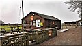
Stan's Bike Shack
This is a famous refreshment stop (in normal times) for cyclists and walkers on the Downs Link path.
Image: © Ian Hawfinch
Taken: 29 Mar 2020
0.00 miles
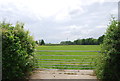
2
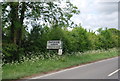
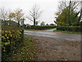
Farm entrance
Entrance to Homelands Farm, Footpath FP2372/2 and The Downs Link.
Image: © The Saunterer
Taken: 26 Oct 2012
0.01 miles
5
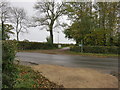
Farm Entrance
To Priors Byne Farm ( The home of Sussex Gold).
Image: © The Saunterer
Taken: 26 Oct 2012
0.03 miles
6
Ordnance Survey Bench mark
Cut Mark "YEW TREE COTT E SIDE RD W FACE SW ANG 10.3815m 0.5m"
Image: © The Saunterer
Taken: 2 Nov 2012
0.04 miles
9
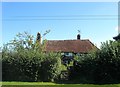
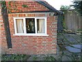
Yew Tree Cottage, Bines Road, Partridge Green
A timber framed cottage dating back to at least the 17th century.
Image: © Simon Carey
Taken: 11 Sep 2016
0.04 miles