IMAGES TAKEN NEAR TO
Hanover Gardens, Alley Groves, HORSHAM, RH13 8DS
Introduction
This page details the photographs taken nearby to Hanover Gardens, Alley Groves, RH13 8DS by members of the Geograph project.
The Geograph project started in 2005 with the aim of publishing, organising and preserving representative images for every square kilometre of Great Britain, Ireland and the Isle of Man.

There are currently over 7.5m images from over14,400 individuals and you can help contribute to the project by visiting https://www.geograph.org.uk
Image Map (Loading...)


Getting Data...Please wait
Leaflet Map data © OpenStreetMap
Images are licensed for reuse under creativecommons.org/licenses/by-sa/2.0
Notes
- Clicking on the map will re-center to the selected point.
- The higher the marker number, the further away the image location is from the centre of the postcode.
Image Listing (181 Images Found)
Images are licensed for reuse under creativecommons.org/licenses/by-sa/2.0
Image
Details
Distance
1
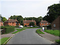
Fairfield Cottages
Built as council housing at the very end of the 1940s.
Image: © Simon Carey
Taken: 4 Sep 2010
0.04 miles
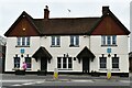
2
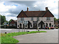
The Hare and Hounds, Cowfold
The Hare and Hounds is a traditional country pub.
Image: © Maigheach-gheal
Taken: 21 Sep 2008
0.07 miles
3
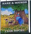
Sign for the Hare and Hounds, Cowfold
Sign for Image
Image: © Maigheach-gheal
Taken: 21 Sep 2008
0.07 miles
4
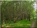
Little Poles
The name of the former field according to the 1840 tithe map part of which now contains housing and the rest has become woodland.
Image: © Simon Carey
Taken: 4 Sep 2010
0.08 miles
5
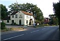
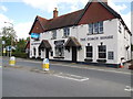
The Coach House Inn
One of two pubs in the village and the oldest. The inn reputedly dates from the 1650s and was known as the Red Lion until at least the end of the 1980s though I'm not sure of the exact date of the name change. The inn grew in importance during the 18th century as the first main London-Brighton route, the current A281, was turnpiked resulting in its expansion. This was further enhanced by the making of a new road, the current A281, in 1825 which nicely located the inn next to the crossroads. The extensive stables are still there but have now been converted into an accommodation block attached to the inn for the use of visitors. Whilst the mode of transport may have changed its nice to see the old coaching inn still retains some of those functions an 18th century traveller may have recognised.
Image: © Simon Carey
Taken: 24 Aug 2010
0.08 miles
6
The Coach House Pub, Cowfold
The pub was closed in Jan 2013 and was looking for a new owner http://www.wscountytimes.co.uk/news/local/landmark-pub-looking-for-a-new-publican-1-4689636
Image: © Paul Gillett
Taken: 15 Aug 2013
0.09 miles
7
Flush Bracket
Ordnance Survey Flush Bracket S9517 Cowfold, Coach House PH.
Image: © The Saunterer
Taken: 18 Jul 2012
0.10 miles
8
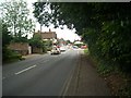
Cowfold Village
Entering Cowfold down Brookhill (A281).
Image: © The Saunterer
Taken: 18 Jul 2012
0.10 miles

10
Cowfold: The Street Co-op convenience store
Image: © Michael Garlick
Taken: 5 Mar 2023
0.10 miles