IMAGES TAKEN NEAR TO
Burnt House Lane, HORSHAM, RH13 8DQ
Introduction
This page details the photographs taken nearby to Burnt House Lane, RH13 8DQ by members of the Geograph project.
The Geograph project started in 2005 with the aim of publishing, organising and preserving representative images for every square kilometre of Great Britain, Ireland and the Isle of Man.

There are currently over 7.5m images from over14,400 individuals and you can help contribute to the project by visiting https://www.geograph.org.uk
Image Map
Images are licensed for reuse under creativecommons.org/licenses/by-sa/2.0
Notes
- Clicking on the map will re-center to the selected point.
- The higher the marker number, the further away the image location is from the centre of the postcode.
Image Listing (25 Images Found)
Images are licensed for reuse under creativecommons.org/licenses/by-sa/2.0
Image
Details
Distance
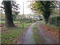
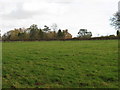
1
Oak lined footpath at bottom of square
More stables in the distance
Image: © Dave Spicer
Taken: 7 Feb 2009
0.06 miles
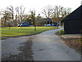
3
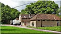
Stables south of High Hurst Manor
This is a cross-grid shot. The camera was in TQ2023.
Image: © Ian Hawfinch
Taken: 1 May 2020
0.08 miles
7
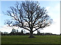
Almost leafless now
This tree is in the grounds of "Ivorys".
Image: © Shazz
Taken: 3 Dec 2016
0.12 miles
9
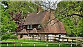
High Hurst Cottages
By my reckoning the half of this building nearest the camera is in TQ2023, and the other half is in TQ2024.
Image: © Ian Hawfinch
Taken: 1 May 2020
0.13 miles