IMAGES TAKEN NEAR TO
Burnt House Lane, HORSHAM, RH13 8DH
Introduction
This page details the photographs taken nearby to Burnt House Lane, RH13 8DH by members of the Geograph project.
The Geograph project started in 2005 with the aim of publishing, organising and preserving representative images for every square kilometre of Great Britain, Ireland and the Isle of Man.

There are currently over 7.5m images from over14,400 individuals and you can help contribute to the project by visiting https://www.geograph.org.uk
Image Map
Images are licensed for reuse under creativecommons.org/licenses/by-sa/2.0
Notes
- Clicking on the map will re-center to the selected point.
- The higher the marker number, the further away the image location is from the centre of the postcode.
Image Listing (40 Images Found)
Images are licensed for reuse under creativecommons.org/licenses/by-sa/2.0
Image
Details
Distance
1
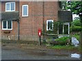
Post Box
Post Box RH13 85 Burnthouse Lane
Image: © The Saunterer
Taken: 10 Jun 2012
0.01 miles
2
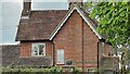
House on Burnthouse Lane
According to the large-scale map this is called "Little Burnt House".
Image: © Ian Hawfinch
Taken: 7 May 2022
0.01 miles
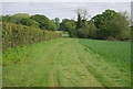
4
Footpath 1809
Footpath 1809 leaves Burnthouse Lane
Image: © The Saunterer
Taken: 10 Jun 2012
0.03 miles
5
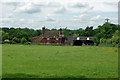
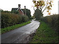
Northfield Farm
On Burnt House Lane, which runs behind the farm in this view.
Image: © Robin Webster
Taken: 9 Jun 2010
0.07 miles
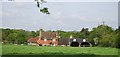
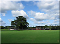
8
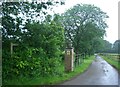
South Burnthouse Field
The name of the field according to the 1840 tithe map that has been expanded to include Burnthouse Field to the north. The house on the right is Little Burnt House whilst Northfield Farm is located at the end of the field.
Image: © Simon Carey
Taken: 24 Aug 2010
0.10 miles
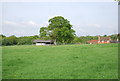
10
House Mead/Hackney
The name of the fields according to the 1840 tithe map. House Mead lies straight ahead between myself and the farmhouse whilst Hackney was to the left. Northfield Farm is the building at the end of the field.
Image: © Simon Carey
Taken: 24 Aug 2010
0.11 miles