IMAGES TAKEN NEAR TO
The Street, HORSHAM, RH13 8BW
Introduction
This page details the photographs taken nearby to The Street, RH13 8BW by members of the Geograph project.
The Geograph project started in 2005 with the aim of publishing, organising and preserving representative images for every square kilometre of Great Britain, Ireland and the Isle of Man.

There are currently over 7.5m images from over14,400 individuals and you can help contribute to the project by visiting https://www.geograph.org.uk
Image Map
Images are licensed for reuse under creativecommons.org/licenses/by-sa/2.0
Notes
- Clicking on the map will re-center to the selected point.
- The higher the marker number, the further away the image location is from the centre of the postcode.
Image Listing (193 Images Found)
Images are licensed for reuse under creativecommons.org/licenses/by-sa/2.0
Image
Details
Distance
1

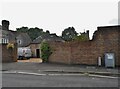
Formerly The Coach House
See Image for when it was a pub / hotel.
Image: © N Chadwick
Taken: 4 May 2014
0.01 miles
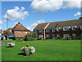
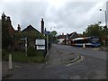
2
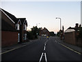
The Street
The old village street which lies between Station Road and Bolney Road briefly combining both the A281 and A272. Taken from the former and looking towards the latter with the village hall a notable landmark at the junction.
Image: © Simon Carey
Taken: 28 Aug 2010
0.02 miles
3
Post Box
Cowfold Post Office RH13 14.
Image: © The Saunterer
Taken: 18 Jul 2012
0.02 miles
4
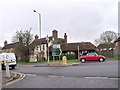
Junction between A 272 and A281, Cowfold, West Sussex
Image: © nick macneill
Taken: 13 Dec 2009
0.02 miles
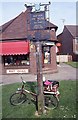
5
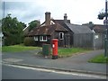
Cowfold Post Office
On a small green opposite the village hall. This is the third site it has had within the village having started out on the current site of the Co-op before moving to another in Station Road which is now a barbers. The houses on the right are part of Fairfield Court.
Image: © Simon Carey
Taken: 28 Aug 2010
0.02 miles
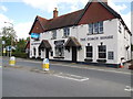
6
St Peter's Cottage and the Old Shop
St Peter's is on the left and dates back to the 15th century, it is currently an Indian restaurant. Joined to it is the Old Shop which dates from the 16th century and was a butchers then more recently an antiques shop and currently a home accessories store called Wattle and Daub. Both are located in The Street with St Peter's church behind them. Taken three minutes before sunrise with the early morning mist just beginning to make itself known.
Image: © Simon Carey
Taken: 4 Sep 2010
0.02 miles
8
The Coach House Pub, Cowfold
The pub was closed in Jan 2013 and was looking for a new owner http://www.wscountytimes.co.uk/news/local/landmark-pub-looking-for-a-new-publican-1-4689636
Image: © Paul Gillett
Taken: 15 Aug 2013
0.02 miles
9
North-south road through Cowfold
The sign announces that the tandoori is "13th century licensed Indian Restaurant".
Is this the oldest Indian restaurant in the UK? Have other restaurants lasted seven or eight centuries?
Image: © David Smith
Taken: 1 May 2014
0.03 miles