IMAGES TAKEN NEAR TO
Burrell Close, HORSHAM, RH13 8BH
Introduction
This page details the photographs taken nearby to Burrell Close, RH13 8BH by members of the Geograph project.
The Geograph project started in 2005 with the aim of publishing, organising and preserving representative images for every square kilometre of Great Britain, Ireland and the Isle of Man.

There are currently over 7.5m images from over14,400 individuals and you can help contribute to the project by visiting https://www.geograph.org.uk
Image Map
Images are licensed for reuse under creativecommons.org/licenses/by-sa/2.0
Notes
- Clicking on the map will re-center to the selected point.
- The higher the marker number, the further away the image location is from the centre of the postcode.
Image Listing (168 Images Found)
Images are licensed for reuse under creativecommons.org/licenses/by-sa/2.0
Image
Details
Distance
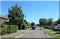
1
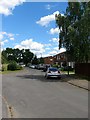
Burrell Close, Partridge Green
A cul de sac off St Michael's Way that was developed in the 1970s on the site of an old field called Cow Field according to West Grinstead's 1841 tithe map.
Image: © Simon Carey
Taken: 31 Jul 2016
0.02 miles
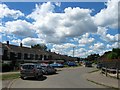
2
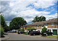
Goring Way, Partridge Green
A cul de sac off Burrell Close that was developed in the 1970s on the site of an old field called Cow Field according to West Grinstead's 1841 tithe map.
Image: © Simon Carey
Taken: 31 Jul 2016
0.03 miles
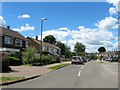
3
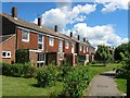
The Causeway, Partridge Green
A set of houses located along a path between St Michaels Way and Oakwood that were built in the 1960s.
Image: © Simon Carey
Taken: 31 Jul 2016
0.05 miles
5
St Michael's Way, Partridge Green
The residential road runs from Oakwood then west and north towards a cul de sac to the immediate south of Image, see Image Originally Cow Field according to West Grinstead's 1841 tithe map it remained in agricultural use until the 1960s when the whole area north of High Street was developed.
Image: © Simon Carey
Taken: 19 Jul 2016
0.06 miles
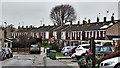
6
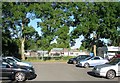
Jolesfield Church of England Primary school, Partridge Green
Viewed from Burrell Close. The current building was erected around 1970 to cater for the rapid growth of Partridge Green replacing an older building to the north on the B2135, see Image, that had been in use since 1873.
Image: © Simon Carey
Taken: 30 Aug 2016
0.06 miles
7
Forresters Road, Partridge Green
A cul de sac off Burrell Close that was built in the 1970s.
Image: © Simon Carey
Taken: 31 Jul 2016
0.07 miles
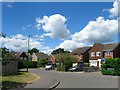
8
Oakwood, Partridge Green
A residential road that links High Street to Littleworth Lane that was developed in the 1960s on the site of a former field called Compass Field according to West Grinstead's 1841 tithe map. This is the view from the junction with Littleworth Lane, see also Image and Image The houses in the distance on the right are part of Image
Image: © Simon Carey
Taken: 31 Jul 2016
0.08 miles
9
Oakwood, Partridge Green
Part of a residential estate built to the north of High Street during the 1960s. The road heads north from High Street then turns east before briefly heading north then east until it ends on Littleworth Lane. This section is the long eastwards straight section that occupies a former field called Stable Field, according to West Grinstead's 1841 tithe map. See also Image and Image
Image: © Simon Carey
Taken: 31 Jul 2016
0.08 miles
10
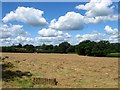
Clapper Mead
The name of the field according to West Grinstead's 1841 tithe map that is bounded by Image to the east and Image to the west. To the south is Partridge Green.
Image: © Simon Carey
Taken: 31 Jul 2016
0.09 miles