IMAGES TAKEN NEAR TO
Bolney Road, HORSHAM, RH13 8AZ
Introduction
This page details the photographs taken nearby to Bolney Road, RH13 8AZ by members of the Geograph project.
The Geograph project started in 2005 with the aim of publishing, organising and preserving representative images for every square kilometre of Great Britain, Ireland and the Isle of Man.

There are currently over 7.5m images from over14,400 individuals and you can help contribute to the project by visiting https://www.geograph.org.uk
Image Map
Images are licensed for reuse under creativecommons.org/licenses/by-sa/2.0
Notes
- Clicking on the map will re-center to the selected point.
- The higher the marker number, the further away the image location is from the centre of the postcode.
Image Listing (23 Images Found)
Images are licensed for reuse under creativecommons.org/licenses/by-sa/2.0
Image
Details
Distance
1
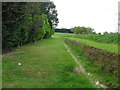
Ditch beside footpath
The Oakendene Industrial Estate is behind the trees on the left
Image: © Dave Spicer
Taken: 25 Apr 2009
0.05 miles
2
Looking north from footpath near Taintfield Wood
Partially hidden by the large Oak is Oakendene Industrial Estate with Oakendene Manor to the right
Image: © Dave Spicer
Taken: 19 Sep 2009
0.06 miles
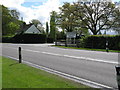
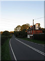
3
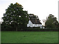
Oakendene Manor Farm Cottages
Lying at the junction of Bolney Road, the A272, and the entrance to Oakenedene Industrial Estate. They built in the first decade of the 20th century.
Image: © Simon Carey
Taken: 30 Aug 2010
0.06 miles
4
Looking north from footpath towards the Oakendene Estate
The white house to the right of picture is Oakendene Manor
Image: © Dave Spicer
Taken: 25 Apr 2009
0.07 miles
5
Entrance to Oakendene Industrial Estate
Image: © Dave Spicer
Taken: 25 Apr 2009
0.07 miles
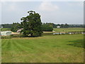
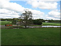
6
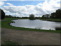
Small lake at the south end of Oakendene Estate
This lake or pond is not even shown on the Explorer map
Image: © Dave Spicer
Taken: 25 Apr 2009
0.10 miles
7
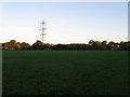
Brook Field
The name of the field according to the 1840 tithe map which takes its name from Cowfold Stream which forms its western boundary. The field has now been expanded to include Sand Field to the south. Coopers Cottage is the building in the distance.
Image: © Simon Carey
Taken: 30 Aug 2010
0.10 miles
8
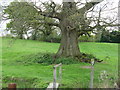
Impressive Oak by footbridge
Beside footpath to Taintfield Wood
Image: © Dave Spicer
Taken: 25 Apr 2009
0.12 miles
9
Coopers Cottage
A 19th century cottage on Bolney Road, the A272. The road beyond this point as only added in 1825 that in view originally being a minor country lane that linked Oakendene with the village of Cowfold.
Image: © Simon Carey
Taken: 30 Aug 2010
0.12 miles
10
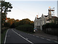
Allfreys House
The Gothic front dates from the early 19th century and was added to what is believed to be a much older building. Bolney Road, the normally busy A272, is nice and quiet twenty minutes after sunrise.
Image: © Simon Carey
Taken: 30 Aug 2010
0.13 miles