IMAGES TAKEN NEAR TO
Mill Farm Road, HORSHAM, RH13 6SL
Introduction
This page details the photographs taken nearby to Mill Farm Road, RH13 6SL by members of the Geograph project.
The Geograph project started in 2005 with the aim of publishing, organising and preserving representative images for every square kilometre of Great Britain, Ireland and the Isle of Man.

There are currently over 7.5m images from over14,400 individuals and you can help contribute to the project by visiting https://www.geograph.org.uk
Image Map
Images are licensed for reuse under creativecommons.org/licenses/by-sa/2.0
Notes
- Clicking on the map will re-center to the selected point.
- The higher the marker number, the further away the image location is from the centre of the postcode.
Image Listing (25 Images Found)
Images are licensed for reuse under creativecommons.org/licenses/by-sa/2.0
Image
Details
Distance
1

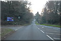
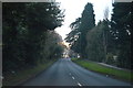
B2195 on the east side of Horsham
Leechpool Wood, a favoured spot for dog walkers, is on the right.
Image: © Dave Spicer
Taken: 24 May 2012
0.13 miles
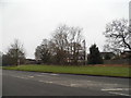
3
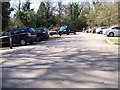
Car park at Leechpool Woods, Horsham, West Sussex
Image: © Elliott Simpson
Taken: 6 Apr 2015
0.14 miles
6
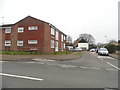
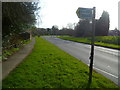
Leechpool Lane at the junction of Crawley Road
Image: © David Howard
Taken: 30 Jan 2017
0.18 miles
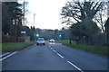
8
Leechpool Woods, Horsham, West Sussex
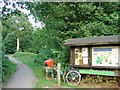
On the fringes of the original St Leonards Forest area. These woods offer a recreation area for the people of Horsham. The overall area (administrated by Horsham District Council) includes Owlbeech and Leechpool Woods. Entrance to the area (where the picture was taken) is through Leechpool woods in grid square TQ1931. Owlbeech woods spread well into TQ2031. The woodland is mixed and includes many mature broadleaved deciduous trees in the Leechpool area. Facilities include a car park, information board, metalled path circuit and a permanent orienteering course. A popular area for dog walkers.
Image: © Pete Chapman
Taken: 13 Jul 2005
0.19 miles